

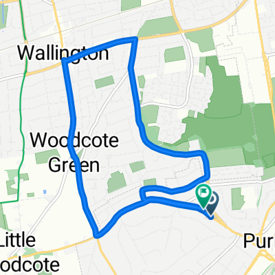
Easy ride in Purley
A cycling route starting in Purley, England, United Kingdom.
Overview
About this route
- 1 h 1 min
- Duration
- 16.3 km
- Distance
- 141 m
- Ascent
- 138 m
- Descent
- 16 km/h
- Avg. speed
- ---
- Max. altitude
Continue with Bikemap
Use, edit, or download this cycling route
You would like to ride Easy ride in Purley or customize it for your own trip? Here is what you can do with this Bikemap route:
Free features
- Save this route as favorite or in collections
- Copy & plan your own version of this route
- Sync your route with Garmin or Wahoo
Premium features
Free trial for 3 days, or one-time payment. More about Bikemap Premium.
- Navigate this route on iOS & Android
- Export a GPX / KML file of this route
- Create your custom printout (try it for free)
- Download this route for offline navigation
Discover more Premium features.
Get Bikemap PremiumFrom our community
Other popular routes starting in Purley
 Restful route in Purley
- Distance
- 8.1 km
- Ascent
- 79 m
- Descent
- 73 m
- Location
- Purley, England, United Kingdom
 Botley Hill Loop
- Distance
- 28 km
- Ascent
- 362 m
- Descent
- 360 m
- Location
- Purley, England, United Kingdom
 N Downs Circuit
- Distance
- 31.5 km
- Ascent
- 391 m
- Descent
- 391 m
- Location
- Purley, England, United Kingdom
 Watney Close 80 to Tilburstow Hill Road
- Distance
- 15.6 km
- Ascent
- 0 m
- Descent
- 8 m
- Location
- Purley, England, United Kingdom
 Kenley - Lingfield - Kenley
- Distance
- 55 km
- Ascent
- 591 m
- Descent
- 587 m
- Location
- Purley, England, United Kingdom
 commute to work
- Distance
- 29.5 km
- Ascent
- 205 m
- Descent
- 250 m
- Location
- Purley, England, United Kingdom
 Boxhill 50km
- Distance
- 50 km
- Ascent
- 457 m
- Descent
- 459 m
- Location
- Purley, England, United Kingdom
 Chalk Pit Lane Ride
- Distance
- 49.1 km
- Ascent
- 533 m
- Descent
- 531 m
- Location
- Purley, England, United Kingdom
Open it in the app