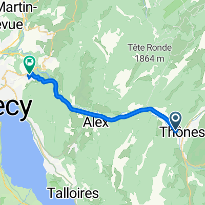
COL DE LA CROIX FRY (por Saint-Jean-de-Sixt)
A cycling route starting in Th么nes, Auvergne-Rh么ne-Alpes, France.
Overview
About this route
- -:--
- Duration
- 18.9 km
- Distance
- 849 m
- Ascent
- 7 m
- Descent
- ---
- Avg. speed
- ---
- Max. altitude
Route quality
Waytypes & surfaces along the route
Waytypes
Access road
0.9 km
(5 %)
Quiet road
0.2 km
(1 %)
Surfaces
Paved
17.2 km
(91 %)
Asphalt
17.2 km
(91 %)
Undefined
1.7 km
(9 %)
Continue with Bikemap
Use, edit, or download this cycling route
You would like to ride COL DE LA CROIX FRY (por Saint-Jean-de-Sixt) or customize it for your own trip? Here is what you can do with this Bikemap route:
Free features
- Save this route as favorite or in collections
- Copy & plan your own version of this route
- Sync your route with Garmin or Wahoo
Premium features
Free trial for 3 days, or one-time payment. More about Bikemap Premium.
- Navigate this route on iOS & Android
- Export a GPX / KML file of this route
- Create your custom printout (try it for free)
- Download this route for offline navigation
Discover more Premium features.
Get Bikemap PremiumFrom our community
Other popular routes starting in Th么nes
JH Manigod -> Thones -> La Clusaz -> Manigod- Distance
- 31.4 km
- Ascent
- 881 m
- Descent
- 881 m
- Location
- Th么nes, Auvergne-Rh么ne-Alpes, France
袨褌 Rue Saint-Blaise 4, Th么nes 写芯 Route de Th么nes 79, Annecy- Distance
- 14.4 km
- Ascent
- 257 m
- Descent
- 301 m
- Location
- Th么nes, Auvergne-Rh么ne-Alpes, France
th么nes et alpages des Confins- Distance
- 17.4 km
- Ascent
- 836 m
- Descent
- 82 m
- Location
- Th么nes, Auvergne-Rh么ne-Alpes, France
Col de la Croix Fry and Col des Aravis- Distance
- 93.7 km
- Ascent
- 2,692 m
- Descent
- 1,873 m
- Location
- Th么nes, Auvergne-Rh么ne-Alpes, France
Col de la Croix Fry and Col des Aravis- Distance
- 48.2 km
- Ascent
- 1,390 m
- Descent
- 1,390 m
- Location
- Th么nes, Auvergne-Rh么ne-Alpes, France
Y - COL CROIX FRY- Distance
- 18.1 km
- Ascent
- 860 m
- Descent
- 258 m
- Location
- Th么nes, Auvergne-Rh么ne-Alpes, France
Day 4 Leg 4 col de la fry to annecy finish!- Distance
- 32.4 km
- Ascent
- 158 m
- Descent
- 1,020 m
- Location
- Th么nes, Auvergne-Rh么ne-Alpes, France
66-560 Thones-Annecy- Distance
- 66.3 km
- Ascent
- 475 m
- Descent
- 474 m
- Location
- Th么nes, Auvergne-Rh么ne-Alpes, France
Open it in the app


