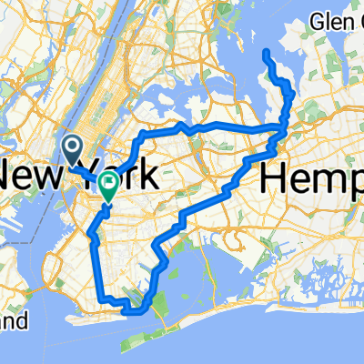
Manhattan: East to West Loop
- 33.9 km
- 164 m
- 165 m
- New York, New York, United States
A cycling route starting in New York, New York, United States.
Overview
A leisurely ride to the coast.
created this 5 years ago
Route quality
Quiet road
11.1 km
(58 %)
Cycleway
3.1 km
(16 %)
Paved
16.1 km
(84 %)
Asphalt
15.1 km
(79 %)
Paved (undefined)
0.4 km
(2 %)
Route highlights
Meet up is at 10 AM, City Hall, across from the Brooklyn Bridge, on Park Row.
Mazzola's Bakery stop @ 10:45a.
Bathroom stop at the McDonald's-Mobil station.
2nd bathroom stop
GRAVSEND TRIANGLE:is named for the first English settlement in New York, Gravesend. Founded in 1645 by Lady Deborah Moody (c.1583-1659), neighbor to Brooklyn’s five Dutch towns, Gravesend developed an air of self-sufficiency that lasted until 1894 when it was finally annexed by the City of Brooklyn. Lady Deborah Moody, a wealthy protestant widow, left England for America in 1639. She and her assemblage of Anabaptists landed in New England, but received a cold welcome from the Puritans who controlled the region. In 1643, she moved to New Amsterdam and, on December 19, 1645, the Dutch governor granted Moody the first town charter written in English in the New World. With that charter, she founded the first English settlement in New York, at the southern end of Brooklyn. An innovative city planner, Moody designed the town after Kent, England, founding its town hall government, starting its first school, and establishing the first church. Gravesend’s design was one of the earliest in the New World to employ a block grid system. The crossroads of the old foursquare town (16 acres) lies just a few blocks to the west, at Gravesend Neck Road and McDonald Avenue. Lady Moody died in 1659. Her grave is located on Gravesend Neck Road between Van Sicklen Street and McDonald Avenue.
TRUMP VILLAGE: The apartment complex was built in 1963–1964 by Fred Trump, the father of Donald Trump. The complex, built on the site of the former Culver Shuttle terminal, . It is the only Trump building complex named for Fred Trump rather than his son Donald.
We should arrive around 12:30. The plunge takes place at 1p., Anyone can take a dip; but to be official, you can sign up (for a donation).
Continue with Bikemap
You would like to ride Polar Bear Ride @ Coney Island or customize it for your own trip? Here is what you can do with this Bikemap route:
Free trial for 3 days, or one-time payment. More about Bikemap Premium.
Discover more Premium features.
Get Bikemap PremiumFrom our community
Open it in the app