
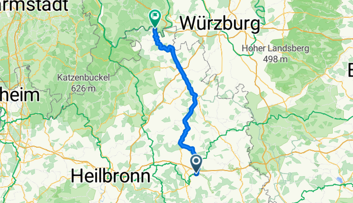
Auf dem Weg nach Wertheim
A cycling route starting in Untermünkheim, Baden-Wurttemberg, Germany.
Overview
About this route
Continue along the Jagst, then over the mountains to reach the Tauber and then to the mouth of the Tauber at Wertheim.
- -:--
- Duration
- 101.9 km
- Distance
- 464 m
- Ascent
- 576 m
- Descent
- ---
- Avg. speed
- ---
- Max. altitude
Route quality
Waytypes & surfaces along the route
Waytypes
Track
55 km
(54 %)
Quiet road
24.4 km
(24 %)
Surfaces
Paved
89.6 km
(88 %)
Unpaved
4.1 km
(4 %)
Asphalt
81.5 km
(80 %)
Paved (undefined)
8.1 km
(8 %)
Continue with Bikemap
Use, edit, or download this cycling route
You would like to ride Auf dem Weg nach Wertheim or customize it for your own trip? Here is what you can do with this Bikemap route:
Free features
- Save this route as favorite or in collections
- Copy & plan your own version of this route
- Split it into stages to create a multi-day tour
- Sync your route with Garmin or Wahoo
Premium features
Free trial for 3 days, or one-time payment. More about Bikemap Premium.
- Navigate this route on iOS & Android
- Export a GPX / KML file of this route
- Create your custom printout (try it for free)
- Download this route for offline navigation
Discover more Premium features.
Get Bikemap PremiumFrom our community
Other popular routes starting in Untermünkheim
 Wackershofen Bhf - SHA - Kochertalradweg - KÜN - Ohrnberg - Öhringen
- Distance
- 71.8 km
- Ascent
- 150 m
- Descent
- 264 m
- Location
- Untermünkheim, Baden-Wurttemberg, Germany
 Untermünkeim - Bühlertal - Tüngental Rennrad
- Distance
- 31.9 km
- Ascent
- 331 m
- Descent
- 329 m
- Location
- Untermünkheim, Baden-Wurttemberg, Germany
 Kochertal Aalen - Schwäbisch Hall - Bad Friedrichsau Tag 2
- Distance
- 73.8 km
- Ascent
- 683 m
- Descent
- 784 m
- Location
- Untermünkheim, Baden-Wurttemberg, Germany
 Obermünkheim - Waldenburg - Frohnfalls - Rottal
- Distance
- 60 km
- Ascent
- 573 m
- Descent
- 573 m
- Location
- Untermünkheim, Baden-Wurttemberg, Germany
 zum Lemberghaus und weiter nach Gnadental
- Distance
- 15.6 km
- Ascent
- 344 m
- Descent
- 227 m
- Location
- Untermünkheim, Baden-Wurttemberg, Germany
 Untermünkeim - Kochertal - Waldenburg Rennrad
- Distance
- 48.1 km
- Ascent
- 313 m
- Descent
- 313 m
- Location
- Untermünkheim, Baden-Wurttemberg, Germany
 Auf dem Weg nach Wertheim
- Distance
- 101.9 km
- Ascent
- 464 m
- Descent
- 576 m
- Location
- Untermünkheim, Baden-Wurttemberg, Germany
 Michelfeld
- Distance
- 19.9 km
- Ascent
- 175 m
- Descent
- 139 m
- Location
- Untermünkheim, Baden-Wurttemberg, Germany
Open it in the app