

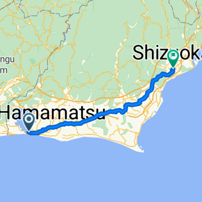
Tokyo-Osaka Day5 (Bentenjima to Tahama/Isewan)
A cycling route starting in Kosai-shi, Shizuoka, Japan.
Overview
About this route
To take the Ferry at Isewan Ferry Irago Office)
- -:--
- Duration
- 67.2 km
- Distance
- 214 m
- Ascent
- 211 m
- Descent
- ---
- Avg. speed
- ---
- Max. altitude

Route quality
Waytypes & surfaces along the route
Waytypes
Quiet road
35.6 km
(53 %)
Road
14.8 km
(22 %)
Surfaces
Paved
10.1 km
(15 %)
Paved (undefined)
9.4 km
(14 %)
Asphalt
0.7 km
(1 %)
Undefined
57.2 km
(85 %)
Continue with Bikemap
Use, edit, or download this cycling route
You would like to ride Tokyo-Osaka Day5 (Bentenjima to Tahama/Isewan) or customize it for your own trip? Here is what you can do with this Bikemap route:
Free features
- Save this route as favorite or in collections
- Copy & plan your own version of this route
- Sync your route with Garmin or Wahoo
Premium features
Free trial for 3 days, or one-time payment. More about Bikemap Premium.
- Navigate this route on iOS & Android
- Export a GPX / KML file of this route
- Create your custom printout (try it for free)
- Download this route for offline navigation
Discover more Premium features.
Get Bikemap PremiumFrom our community
Other popular routes starting in Kosai-shi
 Lake Hamana 2/3周
- Distance
- 40.4 km
- Ascent
- 154 m
- Descent
- 158 m
- Location
- Kosai-shi, Shizuoka, Japan
 2590, Kanzanjicho, Nishi, Hamamatsu a 2380-1, Kanzanjicho, Nishi, Hamamatsu
- Distance
- 51.4 km
- Ascent
- 920 m
- Descent
- 920 m
- Location
- Kosai-shi, Shizuoka, Japan
 07 Kosai to Irago
- Distance
- 59 km
- Ascent
- 351 m
- Descent
- 350 m
- Location
- Kosai-shi, Shizuoka, Japan
 Murakushicho, Nishi-Ku, Hamamatsu-Shi to Murakushicho, Nishi-Ku, Hamamatsu-Shi
- Distance
- 68.8 km
- Ascent
- 0 m
- Descent
- 6 m
- Location
- Kosai-shi, Shizuoka, Japan
 Blistering ride in Gamagori-Shi
- Distance
- 58.1 km
- Ascent
- 7 m
- Descent
- 10 m
- Location
- Kosai-shi, Shizuoka, Japan
 2017/2/8
- Distance
- 93.3 km
- Ascent
- 212 m
- Descent
- 212 m
- Location
- Kosai-shi, Shizuoka, Japan
 Easy ride in Nishi-Ku, Hamamatsu-Shi
- Distance
- 41.8 km
- Ascent
- 417 m
- Descent
- 419 m
- Location
- Kosai-shi, Shizuoka, Japan
 Бентендзима Шидзуока
- Distance
- 98.7 km
- Ascent
- 993 m
- Descent
- 965 m
- Location
- Kosai-shi, Shizuoka, Japan
Open it in the app