

Trajet_Vers_Lattes
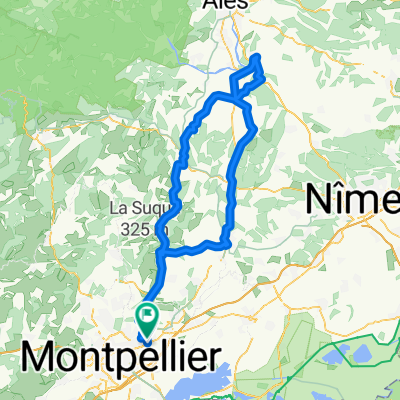
A cycling route starting in Le Crès, Occitanie, France.
Overview
About this route
- -:--
- Duration
- 15.5 km
- Distance
- 39 m
- Ascent
- 78 m
- Descent
- ---
- Avg. speed
- ---
- Max. altitude

Route quality
Waytypes & surfaces along the route
Waytypes
Path
4.9 km
(32 %)
Cycleway
4.9 km
(32 %)
Surfaces
Paved
10.4 km
(67 %)
Asphalt
7.9 km
(51 %)
Concrete
1.8 km
(12 %)
Continue with Bikemap
Use, edit, or download this cycling route
You would like to ride Trajet_Vers_Lattes or customize it for your own trip? Here is what you can do with this Bikemap route:
Free features
- Save this route as favorite or in collections
- Copy & plan your own version of this route
- Sync your route with Garmin or Wahoo
Premium features
Free trial for 3 days, or one-time payment. More about Bikemap Premium.
- Navigate this route on iOS & Android
- Export a GPX / KML file of this route
- Create your custom printout (try it for free)
- Download this route for offline navigation
Discover more Premium features.
Get Bikemap PremiumFrom our community
Other popular routes starting in Le Crès
 PB - J10 - Montpellier beziers
- Distance
- 94.6 km
- Ascent
- 73 m
- Descent
- 83 m
- Location
- Le Crès, Occitanie, France
 session triathlon
- Distance
- 42.6 km
- Ascent
- 267 m
- Descent
- 265 m
- Location
- Le Crès, Occitanie, France
 710 Avenue Blaise Pascal, Castelnau-le-Lez à 265 Avenue des États du Languedoc, Montpellier
- Distance
- 7.1 km
- Ascent
- 156 m
- Descent
- 195 m
- Location
- Le Crès, Occitanie, France
 Boulevard Est de Liaison, Castelnau-le-Lez à GR 653 Voie d'Arles d'Arles à Montpellier, Le Crès
- Distance
- 3.9 km
- Ascent
- 45 m
- Descent
- 39 m
- Location
- Le Crès, Occitanie, France
 730 Avenue Blaise Pascal, Castelnau-le-Lez à 1 Rue des Pertuisanes, Montpellier
- Distance
- 6.8 km
- Ascent
- 33 m
- Descent
- 75 m
- Location
- Le Crès, Occitanie, France
 VEZENOBRE
- Distance
- 130.5 km
- Ascent
- 488 m
- Descent
- 476 m
- Location
- Le Crès, Occitanie, France
 Trajet_Vers_Lattes
- Distance
- 15.5 km
- Ascent
- 39 m
- Descent
- 78 m
- Location
- Le Crès, Occitanie, France
 tour de l'etang de l'or
- Distance
- 65.2 km
- Ascent
- 72 m
- Descent
- 75 m
- Location
- Le Crès, Occitanie, France
Open it in the app