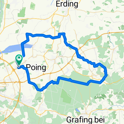
gwerger
A cycling route starting in Kirchheim bei München, Bavaria, Germany.
Overview
About this route
- -:--
- Duration
- 55.2 km
- Distance
- 71 m
- Ascent
- 68 m
- Descent
- ---
- Avg. speed
- ---
- Avg. speed
Route quality
Waytypes & surfaces along the route
Waytypes
Quiet road
29.1 km
(53 %)
Path
12.8 km
(23 %)
Surfaces
Paved
43.8 km
(79 %)
Unpaved
5.8 km
(10 %)
Asphalt
42.7 km
(77 %)
Gravel
4.6 km
(8 %)
Continue with Bikemap
Use, edit, or download this cycling route
You would like to ride gwerger or customize it for your own trip? Here is what you can do with this Bikemap route:
Free features
- Save this route as favorite or in collections
- Copy & plan your own version of this route
- Sync your route with Garmin or Wahoo
Premium features
Free trial for 3 days, or one-time payment. More about Bikemap Premium.
- Navigate this route on iOS & Android
- Export a GPX / KML file of this route
- Create your custom printout (try it for free)
- Download this route for offline navigation
Discover more Premium features.
Get Bikemap PremiumFrom our community
Other popular routes starting in Kirchheim bei München
- Rotdornweg 6, Kirchheim bei München nach Rotdornweg 6, Kirchheim bei München
- Distance
- 9.3 km
- Ascent
- 550 m
- Descent
- 605 m
- Location
- Kirchheim bei München, Bavaria, Germany
- Runde West
- Distance
- 67.4 km
- Ascent
- 241 m
- Descent
- 244 m
- Location
- Kirchheim bei München, Bavaria, Germany
- Richard-Strauss-Straße 8A, Kirchheim bei München nach Heimstettner Straße 2A, Kirchheim bei München
- Distance
- 19 km
- Ascent
- 19 m
- Descent
- 18 m
- Location
- Kirchheim bei München, Bavaria, Germany
- Gut Birkenhof
- Distance
- 18.7 km
- Ascent
- 13 m
- Descent
- 13 m
- Location
- Kirchheim bei München, Bavaria, Germany
- kirchheim - unterföhring
- Distance
- 24.7 km
- Ascent
- 285 m
- Descent
- 307 m
- Location
- Kirchheim bei München, Bavaria, Germany
- gwerger
- Distance
- 55.2 km
- Ascent
- 71 m
- Descent
- 68 m
- Location
- Kirchheim bei München, Bavaria, Germany
- HMTB-Isar-Inn-63km
- Distance
- 63.4 km
- Ascent
- 124 m
- Descent
- 123 m
- Location
- Kirchheim bei München, Bavaria, Germany
- Rund ums Ostkreuz V1
- Distance
- 21.9 km
- Ascent
- 24 m
- Descent
- 23 m
- Location
- Kirchheim bei München, Bavaria, Germany
Open it in the app