

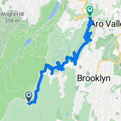
Mine to Lin's
A cycling route starting in Brooklyn, Wellington Region, New Zealand.
Overview
About this route
Bush tracks, minimal footpath. A bit hilly but great vistas
- -:--
- Duration
- 4.9 km
- Distance
- 206 m
- Ascent
- 222 m
- Descent
- ---
- Avg. speed
- ---
- Max. altitude

Continue with Bikemap
Use, edit, or download this cycling route
You would like to ride Mine to Lin's or customize it for your own trip? Here is what you can do with this Bikemap route:
Free features
- Save this route as favorite or in collections
- Copy & plan your own version of this route
- Sync your route with Garmin or Wahoo
Premium features
Free trial for 3 days, or one-time payment. More about Bikemap Premium.
- Navigate this route on iOS & Android
- Export a GPX / KML file of this route
- Create your custom printout (try it for free)
- Download this route for offline navigation
Discover more Premium features.
Get Bikemap PremiumFrom our community
Other popular routes starting in Brooklyn
 Alternative Red Rocks loop
- Distance
- 7.5 km
- Ascent
- 468 m
- Descent
- 469 m
- Location
- Brooklyn, Wellington Region, New Zealand
 Quick bike tour through Pencarrow Head
- Distance
- 7.6 km
- Ascent
- 134 m
- Descent
- 202 m
- Location
- Brooklyn, Wellington Region, New Zealand
 Sweet Town Belt 15km
- Distance
- 15.3 km
- Ascent
- 484 m
- Descent
- 485 m
- Location
- Brooklyn, Wellington Region, New Zealand
 Lighthouse Track, Pencarrow Head to 434 Muritai Road, Muritai
- Distance
- 9.2 km
- Ascent
- 42 m
- Descent
- 126 m
- Location
- Brooklyn, Wellington Region, New Zealand
 Extendo Tip Loop from home
- Distance
- 18 km
- Ascent
- 831 m
- Descent
- 830 m
- Location
- Brooklyn, Wellington Region, New Zealand
 Virginia to Hosp via Te Aro
- Distance
- 9.5 km
- Ascent
- 267 m
- Descent
- 266 m
- Location
- Brooklyn, Wellington Region, New Zealand
 Goind down from Windmill
- Distance
- 5.7 km
- Ascent
- ---
- Descent
- ---
- Location
- Brooklyn, Wellington Region, New Zealand
 Radome Track Xtended
- Distance
- 13.8 km
- Ascent
- 613 m
- Descent
- 938 m
- Location
- Brooklyn, Wellington Region, New Zealand
Open it in the app