

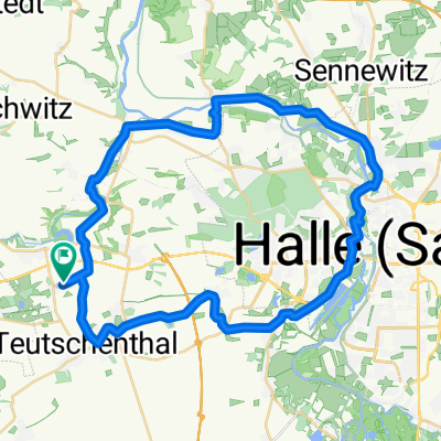
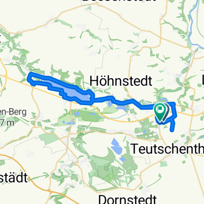
Langenbogen - Zaschwitz - Langenbogen
A cycling route starting in Langenbogen, Saxony-Anhalt, Germany.
Overview
About this route
- -:--
- Duration
- 32.2 km
- Distance
- 229 m
- Ascent
- 226 m
- Descent
- ---
- Avg. speed
- ---
- Max. altitude

Route quality
Waytypes & surfaces along the route
Waytypes
Road
7.1 km
(22 %)
Living street
1 km
(3 %)
Surfaces
Paved
26.1 km
(81 %)
Unpaved
1 km
(3 %)
Asphalt
26.1 km
(81 %)
Gravel
1 km
(3 %)
Undefined
5.2 km
(16 %)
Continue with Bikemap
Use, edit, or download this cycling route
You would like to ride Langenbogen - Zaschwitz - Langenbogen or customize it for your own trip? Here is what you can do with this Bikemap route:
Free features
- Save this route as favorite or in collections
- Copy & plan your own version of this route
- Sync your route with Garmin or Wahoo
Premium features
Free trial for 3 days, or one-time payment. More about Bikemap Premium.
- Navigate this route on iOS & Android
- Export a GPX / KML file of this route
- Create your custom printout (try it for free)
- Download this route for offline navigation
Discover more Premium features.
Get Bikemap PremiumFrom our community
Other popular routes starting in Langenbogen
 Köchstedter Straße 21, Teutschenthal nach Köchstedter Straße 21, Teutschenthal
- Distance
- 30.2 km
- Ascent
- 271 m
- Descent
- 270 m
- Location
- Langenbogen, Saxony-Anhalt, Germany
 Einfache Fahrt in Salzatal
- Distance
- 0.1 km
- Ascent
- 0 m
- Descent
- 0 m
- Location
- Langenbogen, Saxony-Anhalt, Germany
 langenbogen-budapest through regensburg
- Distance
- 1,121 km
- Ascent
- 1,061 m
- Descent
- 1,043 m
- Location
- Langenbogen, Saxony-Anhalt, Germany
 Köchstedter Straße, Teutschenthal nach Köchstedter Straße, Teutschenthal
- Distance
- 43.2 km
- Ascent
- 283 m
- Descent
- 284 m
- Location
- Langenbogen, Saxony-Anhalt, Germany
 Radrunde durch Teutschenthal
- Distance
- 25.6 km
- Ascent
- 103 m
- Descent
- 103 m
- Location
- Langenbogen, Saxony-Anhalt, Germany
 Teichstraße 36A, Teutschenthal nach Teichstraße 36A, Teutschenthal
- Distance
- 17.6 km
- Ascent
- 64 m
- Descent
- 65 m
- Location
- Langenbogen, Saxony-Anhalt, Germany
 Köchstedter Straße, Teutschenthal nach Köchstedter Straße, Teutschenthal
- Distance
- 33.9 km
- Ascent
- 230 m
- Descent
- 235 m
- Location
- Langenbogen, Saxony-Anhalt, Germany
 Cachen
- Distance
- 13 km
- Ascent
- 87 m
- Descent
- 88 m
- Location
- Langenbogen, Saxony-Anhalt, Germany
Open it in the app