

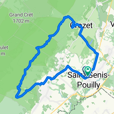
Fast ride in Saint-Genis-Pouilly
A cycling route starting in Saint-Genis-Pouilly, Auvergne-Rhône-Alpes, France.
Overview
About this route
- 1 h 15 min
- Duration
- 24.2 km
- Distance
- 644 m
- Ascent
- 634 m
- Descent
- 19.2 km/h
- Avg. speed
- ---
- Max. altitude

Route photos


Continue with Bikemap
Use, edit, or download this cycling route
You would like to ride Fast ride in Saint-Genis-Pouilly or customize it for your own trip? Here is what you can do with this Bikemap route:
Free features
- Save this route as favorite or in collections
- Copy & plan your own version of this route
- Sync your route with Garmin or Wahoo
Premium features
Free trial for 3 days, or one-time payment. More about Bikemap Premium.
- Navigate this route on iOS & Android
- Export a GPX / KML file of this route
- Create your custom printout (try it for free)
- Download this route for offline navigation
Discover more Premium features.
Get Bikemap PremiumFrom our community
Other popular routes starting in Saint-Genis-Pouilly
 Allee des Ormes 32, Saint-Genis-Pouilly to Allee des Ormes 32, Saint-Genis-Pouilly
- Distance
- 24.5 km
- Ascent
- 215 m
- Descent
- 217 m
- Location
- Saint-Genis-Pouilly, Auvergne-Rhône-Alpes, France
 Kolecko k Source d'Alondon cez obed
- Distance
- 18.2 km
- Ascent
- 367 m
- Descent
- 358 m
- Location
- Saint-Genis-Pouilly, Auvergne-Rhône-Alpes, France
 Fast ride in Saint-Genis-Pouilly
- Distance
- 24.2 km
- Ascent
- 644 m
- Descent
- 634 m
- Location
- Saint-Genis-Pouilly, Auvergne-Rhône-Alpes, France
 Pays de Gex 1.1
- Distance
- 40.3 km
- Ascent
- 348 m
- Descent
- 347 m
- Location
- Saint-Genis-Pouilly, Auvergne-Rhône-Alpes, France
 St Genis circuit (short)
- Distance
- 20.9 km
- Ascent
- 206 m
- Descent
- 204 m
- Location
- Saint-Genis-Pouilly, Auvergne-Rhône-Alpes, France
 Thoiry up
- Distance
- 9.6 km
- Ascent
- 465 m
- Descent
- 304 m
- Location
- Saint-Genis-Pouilly, Auvergne-Rhône-Alpes, France
 Motanie sa okolo Tiocan
- Distance
- 36.1 km
- Ascent
- 988 m
- Descent
- 987 m
- Location
- Saint-Genis-Pouilly, Auvergne-Rhône-Alpes, France
 Saint Genis - Tiocan - Crozet - Saint Genis
- Distance
- 23.1 km
- Ascent
- 547 m
- Descent
- 540 m
- Location
- Saint-Genis-Pouilly, Auvergne-Rhône-Alpes, France
Open it in the app