

Chiusaforte-Prato di Resia-Ruscjis-Chiusaforte
A cycling route starting in Chiusaforte, Friuli Venezia Giulia, Italy.
Overview
About this route
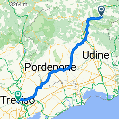
Partenza da Chiusaforte con direzione Resiutta, percorrendo prima la ss13 poi la pista ciclabile fvg1 poi da Resiutta fino a Prato di Resia, tratto su asfalto, a Prato dopo la chiesa si svolta a dx e si imbocca la strada forestale sterrata che porta a sella Segata, per 5 km si sale parecchio, al bivio dove si trova l'icona del cristo si svolta a sx e si prosegue verso stavoli Ruscjis ( senza indicazioni) ai quali si giunge dopo una decina di km di sali-scendi. Dopo un'ultima serie di tornanti si arriva al ripetitore, punto più alto e panoramico. Da lì inizia la discesa a fondo valle fino alla provinciale della Val Resia, che si percorre verso Resiutta ed in fine verso Chiusaforte.
Si consiglia allenamento, la salita sullo sterrato è impegnativa.
- -:--
- Duration
- 38.5 km
- Distance
- 805 m
- Ascent
- 806 m
- Descent
- ---
- Avg. speed
- ---
- Max. altitude
Continue with Bikemap
Use, edit, or download this cycling route
You would like to ride Chiusaforte-Prato di Resia-Ruscjis-Chiusaforte or customize it for your own trip? Here is what you can do with this Bikemap route:
Free features
- Save this route as favorite or in collections
- Copy & plan your own version of this route
- Sync your route with Garmin or Wahoo
Premium features
Free trial for 3 days, or one-time payment. More about Bikemap Premium.
- Navigate this route on iOS & Android
- Export a GPX / KML file of this route
- Create your custom printout (try it for free)
- Download this route for offline navigation
Discover more Premium features.
Get Bikemap PremiumFrom our community
Other popular routes starting in Chiusaforte
 Chiusaforte - Azzano Decimo
- Distance
- 159.4 km
- Ascent
- 665 m
- Descent
- 1,046 m
- Location
- Chiusaforte, Friuli Venezia Giulia, Italy
 Via Roma nach Venzone
- Distance
- 22.2 km
- Ascent
- 442 m
- Descent
- 596 m
- Location
- Chiusaforte, Friuli Venezia Giulia, Italy
 #Friaul Raccolana - Sella Nevea - Bovec - Vrsic - Tarvis
- Distance
- 103.9 km
- Ascent
- 2,230 m
- Descent
- 1,860 m
- Location
- Chiusaforte, Friuli Venezia Giulia, Italy
 Pecol-Nasfeld KochahMautern-TreCroci-Paularo-Zermula-Ponteba- Nevea.Pecol
- Distance
- 196 km
- Ascent
- 4,135 m
- Descent
- 4,130 m
- Location
- Chiusaforte, Friuli Venezia Giulia, Italy
 Runde Sella Nevea Tarvis Kanaltal
- Distance
- 74.7 km
- Ascent
- 961 m
- Descent
- 961 m
- Location
- Chiusaforte, Friuli Venezia Giulia, Italy
 2015.06.24 Chiusaforte-Sonnleiten
- Distance
- 81.3 km
- Ascent
- 1,866 m
- Descent
- 830 m
- Location
- Chiusaforte, Friuli Venezia Giulia, Italy
 Ciclovia Alpe Adria (tratta da Chiusaforte a Valbruna)
- Distance
- 30.7 km
- Ascent
- 532 m
- Descent
- 142 m
- Location
- Chiusaforte, Friuli Venezia Giulia, Italy
 Da Via Stazione a Bahnhofstraße
- Distance
- 67.5 km
- Ascent
- 1,208 m
- Descent
- 1,113 m
- Location
- Chiusaforte, Friuli Venezia Giulia, Italy
Open it in the app