

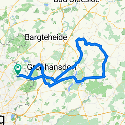
Sasel, Öjendorfer See, Dove-Elbe, Wasserkunst, Alster, Stadtpark, Ohlsdofer Friedhof, Sasel
A cycling route starting in Sasel, City state of Hamburg, Germany.
Overview
About this route
null
- 5 h 10 min
- Duration
- 61 km
- Distance
- 102 m
- Ascent
- 104 m
- Descent
- 11.8 km/h
- Avg. speed
- ---
- Max. altitude

Route quality
Waytypes & surfaces along the route
Waytypes
Quiet road
19.5 km
(32 %)
Pedestrian area
15.9 km
(26 %)
Surfaces
Paved
33.6 km
(55 %)
Unpaved
12.8 km
(21 %)
Asphalt
32.9 km
(54 %)
Gravel
9.2 km
(15 %)
Continue with Bikemap
Use, edit, or download this cycling route
You would like to ride Sasel, Öjendorfer See, Dove-Elbe, Wasserkunst, Alster, Stadtpark, Ohlsdofer Friedhof, Sasel or customize it for your own trip? Here is what you can do with this Bikemap route:
Free features
- Save this route as favorite or in collections
- Copy & plan your own version of this route
- Sync your route with Garmin or Wahoo
Premium features
Free trial for 3 days, or one-time payment. More about Bikemap Premium.
- Navigate this route on iOS & Android
- Export a GPX / KML file of this route
- Create your custom printout (try it for free)
- Download this route for offline navigation
Discover more Premium features.
Get Bikemap PremiumFrom our community
Other popular routes starting in Sasel
 Volksdorfer Runde
- Distance
- 69.7 km
- Ascent
- 239 m
- Descent
- 240 m
- Location
- Sasel, City state of Hamburg, Germany
 Winterunde Sasel Ahrensburg Sasel
- Distance
- 27.7 km
- Ascent
- 114 m
- Descent
- 118 m
- Location
- Sasel, City state of Hamburg, Germany
 Hüttbleker Runde
- Distance
- 76.6 km
- Ascent
- 297 m
- Descent
- 307 m
- Location
- Sasel, City state of Hamburg, Germany
 50 km um den Lütjensee
- Distance
- 50.1 km
- Ascent
- 153 m
- Descent
- 153 m
- Location
- Sasel, City state of Hamburg, Germany
 Von Sasel durch den Höltingbaum
- Distance
- 25.6 km
- Ascent
- 94 m
- Descent
- 94 m
- Location
- Sasel, City state of Hamburg, Germany
 Hamburg-Volksdorf
- Distance
- 81.3 km
- Ascent
- 285 m
- Descent
- 297 m
- Location
- Sasel, City state of Hamburg, Germany
 Sasel -Duvenstedter Brook - Sasel
- Distance
- 32.2 km
- Ascent
- 69 m
- Descent
- 71 m
- Location
- Sasel, City state of Hamburg, Germany
 Von Sasel durch den Ohlsdorfer Friedhof
- Distance
- 20.2 km
- Ascent
- 92 m
- Descent
- 90 m
- Location
- Sasel, City state of Hamburg, Germany
Open it in the app