

Culver Trail
A cycling route starting in Bembridge, England, United Kingdom.
Overview
About this route
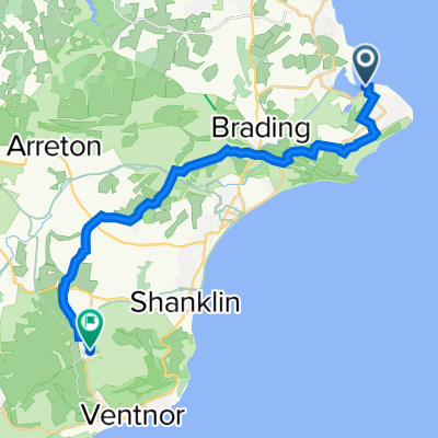
The Culver Trail - from Bembridge village down the hill past Bembridge Windmill to the Airport - up Culver Down and then following the Coastal Path back to Bembridge.
- -:--
- Duration
- 8.9 km
- Distance
- 119 m
- Ascent
- 119 m
- Descent
- ---
- Avg. speed
- ---
- Max. altitude

Continue with Bikemap
Use, edit, or download this cycling route
You would like to ride Culver Trail or customize it for your own trip? Here is what you can do with this Bikemap route:
Free features
- Save this route as favorite or in collections
- Copy & plan your own version of this route
- Sync your route with Garmin or Wahoo
Premium features
Free trial for 3 days, or one-time payment. More about Bikemap Premium.
- Navigate this route on iOS & Android
- Export a GPX / KML file of this route
- Create your custom printout (try it for free)
- Download this route for offline navigation
Discover more Premium features.
Get Bikemap PremiumFrom our community
Other popular routes starting in Bembridge
 The Duver, St. Helens, St Helens, Ryde to 2 Holmwood Close, Bembridge
- Distance
- 5.1 km
- Ascent
- 52 m
- Descent
- 40 m
- Location
- Bembridge, England, United Kingdom
 The Ark, Embankment Road, Bembridge to Esplanade, Wight
- Distance
- 9.6 km
- Ascent
- 0 m
- Descent
- 3 m
- Location
- Bembridge, England, United Kingdom
 Solent Landing, 1 Beach Road, Bembridge to London House, High St, Ventnor
- Distance
- 19.1 km
- Ascent
- 295 m
- Descent
- 214 m
- Location
- Bembridge, England, United Kingdom
 Whitecliff Bay Holiday Park, Hillway Road, Bembridge to Ferry House, The Duver, Ryde
- Distance
- 7 km
- Ascent
- 60 m
- Descent
- 81 m
- Location
- Bembridge, England, United Kingdom
 Seamark House, The Duver, Ryde to 21 High St, Bembridge
- Distance
- 3.6 km
- Ascent
- 49 m
- Descent
- 29 m
- Location
- Bembridge, England, United Kingdom
 Houseboat Marks Ark, Embankment Road, Bembridge to 10 St Thomas Square, Ryde
- Distance
- 9.5 km
- Ascent
- 134 m
- Descent
- 98 m
- Location
- Bembridge, England, United Kingdom
 6 The Lanterns, Sherbourne St, Bembridge to Rowborough Lane, Brading, Sandown
- Distance
- 8.6 km
- Ascent
- 113 m
- Descent
- 121 m
- Location
- Bembridge, England, United Kingdom
 warner hotel
- Distance
- 19.3 km
- Ascent
- 216 m
- Descent
- 202 m
- Location
- Bembridge, England, United Kingdom
Open it in the app