

le tour de Kamp-Lintfort
A cycling route starting in Kamp-Lintfort, North Rhine-Westphalia, Germany.
Overview
About this route
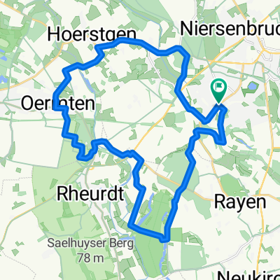
Tour with many attractions such as the Halde Norddeutschland and the mining facility BW-West. You can also take a break for rest and food at the Samanshof. Furthermore, boat rental is available at Samanshof. On the way back, you pass (n. W.) the Vlynbusch forest, which is particularly noted for mountain bikers. Have fun and enjoy your tour! O.Broll
- -:--
- Duration
- 17.7 km
- Distance
- 33 m
- Ascent
- 27 m
- Descent
- ---
- Avg. speed
- 37 m
- Max. altitude
Route quality
Waytypes & surfaces along the route
Waytypes
Quiet road
9.2 km
(52 %)
Road
2.7 km
(15 %)
Surfaces
Paved
14.5 km
(82 %)
Unpaved
0.7 km
(4 %)
Asphalt
14.5 km
(82 %)
Gravel
0.7 km
(4 %)
Undefined
2.5 km
(14 %)
Continue with Bikemap
Use, edit, or download this cycling route
You would like to ride le tour de Kamp-Lintfort or customize it for your own trip? Here is what you can do with this Bikemap route:
Free features
- Save this route as favorite or in collections
- Copy & plan your own version of this route
- Sync your route with Garmin or Wahoo
Premium features
Free trial for 3 days, or one-time payment. More about Bikemap Premium.
- Navigate this route on iOS & Android
- Export a GPX / KML file of this route
- Create your custom printout (try it for free)
- Download this route for offline navigation
Discover more Premium features.
Get Bikemap PremiumFrom our community
Other popular routes starting in Kamp-Lintfort
 Drei Haldentour
- Distance
- 35.7 km
- Ascent
- 221 m
- Descent
- 223 m
- Location
- Kamp-Lintfort, North Rhine-Westphalia, Germany
 le tour de Kamp-Lintfort
- Distance
- 17.7 km
- Ascent
- 33 m
- Descent
- 27 m
- Location
- Kamp-Lintfort, North Rhine-Westphalia, Germany
 Kamp_Lintfort - Xanten um Nord und Südsee
- Distance
- 61.4 km
- Ascent
- 196 m
- Descent
- 196 m
- Location
- Kamp-Lintfort, North Rhine-Westphalia, Germany
 Lintfort - Oermter Berg - Lintfort
- Distance
- 23.3 km
- Ascent
- 86 m
- Descent
- 85 m
- Location
- Kamp-Lintfort, North Rhine-Westphalia, Germany
 Route Kohlenhuk
- Distance
- 26.1 km
- Ascent
- 97 m
- Descent
- 98 m
- Location
- Kamp-Lintfort, North Rhine-Westphalia, Germany
 Die Leucht 3
- Distance
- 32 km
- Ascent
- 123 m
- Descent
- 125 m
- Location
- Kamp-Lintfort, North Rhine-Westphalia, Germany
 Frankys Runde, Pattberg, Homberg,Essenberg, Kaßlerfeld, Walsum, Orsoy, Budberg, Pattberg
- Distance
- 52.5 km
- Ascent
- 124 m
- Descent
- 122 m
- Location
- Kamp-Lintfort, North Rhine-Westphalia, Germany
 Die Leucht-Route
- Distance
- 24.8 km
- Ascent
- 101 m
- Descent
- 103 m
- Location
- Kamp-Lintfort, North Rhine-Westphalia, Germany
Open it in the app