

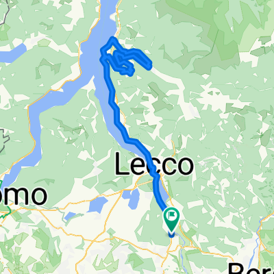
ParcoAddaNord-ValSanMartino-MonteCanto
A cycling route starting in Airuno, Lombardy, Italy.
Overview
About this route
- -:--
- Duration
- 29.6 km
- Distance
- 860 m
- Ascent
- 847 m
- Descent
- ---
- Avg. speed
- ---
- Max. altitude

Continue with Bikemap
Use, edit, or download this cycling route
You would like to ride ParcoAddaNord-ValSanMartino-MonteCanto or customize it for your own trip? Here is what you can do with this Bikemap route:
Free features
- Save this route as favorite or in collections
- Copy & plan your own version of this route
- Sync your route with Garmin or Wahoo
Premium features
Free trial for 3 days, or one-time payment. More about Bikemap Premium.
- Navigate this route on iOS & Android
- Export a GPX / KML file of this route
- Create your custom printout (try it for free)
- Download this route for offline navigation
Discover more Premium features.
Get Bikemap PremiumFrom our community
Other popular routes starting in Airuno
 Airuno-Blenno-Culmine-Valsassina-Airuno
- Distance
- 146.4 km
- Ascent
- 1,689 m
- Descent
- 1,690 m
- Location
- Airuno, Lombardy, Italy
 Passo Agueglio
- Distance
- 110.8 km
- Ascent
- 1,103 m
- Descent
- 1,104 m
- Location
- Airuno, Lombardy, Italy
 Airuno-Roncola-Val taleggio- Culmine-Airuno
- Distance
- 107.1 km
- Ascent
- 1,989 m
- Descent
- 1,985 m
- Location
- Airuno, Lombardy, Italy
 Airuno-Resinelli
- Distance
- 72.9 km
- Ascent
- 1,431 m
- Descent
- 1,432 m
- Location
- Airuno, Lombardy, Italy
 mappa abdua
- Distance
- 30.9 km
- Ascent
- 120 m
- Descent
- 184 m
- Location
- Airuno, Lombardy, Italy
 Aiuruno-Roncola-Berbenno-Valsecca
- Distance
- 109.2 km
- Ascent
- 2,752 m
- Descent
- 2,748 m
- Location
- Airuno, Lombardy, Italy
 ParcoAddaNord-ValSanMartino-MonteCanto
- Distance
- 29.6 km
- Ascent
- 860 m
- Descent
- 847 m
- Location
- Airuno, Lombardy, Italy
 Airuno-Serina-Val taleggio- Culmine- Aiurno
- Distance
- 120.1 km
- Ascent
- 1,944 m
- Descent
- 1,941 m
- Location
- Airuno, Lombardy, Italy
Open it in the app