

Berlijn Dag 2 Etappe 4
A cycling route starting in Hansaviertel, State of Berlin, Germany.
Overview
About this route
Bikini/HamburgeBhf
- -:--
- Duration
- 5.3 km
- Distance
- 36 m
- Ascent
- 50 m
- Descent
- ---
- Avg. speed
- ---
- Max. altitude

Route quality
Waytypes & surfaces along the route
Waytypes
Pedestrian area
1.5 km
(29 %)
Cycleway
1.5 km
(29 %)
Surfaces
Paved
3.4 km
(65 %)
Asphalt
3.3 km
(62 %)
Paved (undefined)
0.2 km
(3 %)
Undefined
1.8 km
(35 %)
Route highlights
Points of interest along the route
Point of interest after 0 km
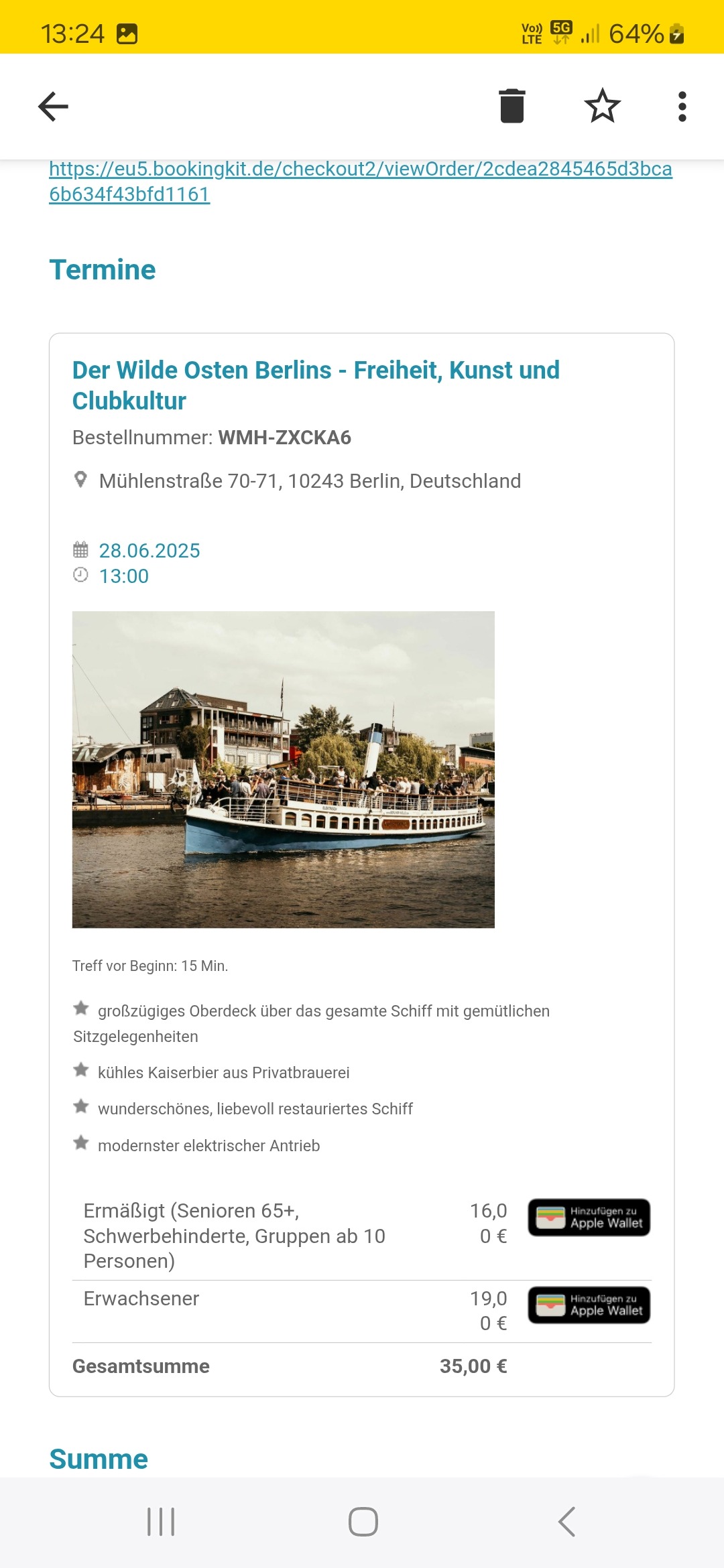
Mahnmal Gleis 17
Point of interest after 0.1 km
Bikini Berlin
Accommodation after 4 km
Metropolhostel
Point of interest after 4.4 km
RAW Gelände
Point of interest after 4.4 km
Resttaurant Burgeramt
Point of interest after 4.4 km
East Side Gallery
Point of interest after 5.3 km
Hamburger Bhf
Continue with Bikemap
Use, edit, or download this cycling route
You would like to ride Berlijn Dag 2 Etappe 4 or customize it for your own trip? Here is what you can do with this Bikemap route:
Free features
- Save this route as favorite or in collections
- Copy & plan your own version of this route
- Sync your route with Garmin or Wahoo
Premium features
Free trial for 3 days, or one-time payment. More about Bikemap Premium.
- Navigate this route on iOS & Android
- Export a GPX / KML file of this route
- Create your custom printout (try it for free)
- Download this route for offline navigation
Discover more Premium features.
Get Bikemap PremiumFrom our community
Other popular routes starting in Hansaviertel
 Moabit-Fahrland-Henningsdorf-Moabit
- Distance
- 107 km
- Ascent
- 128 m
- Descent
- 130 m
- Location
- Hansaviertel, State of Berlin, Germany
 Berlijn Dag 2 Etappe 4 EV
- Distance
- 5.2 km
- Ascent
- 60 m
- Descent
- 70 m
- Location
- Hansaviertel, State of Berlin, Germany
 BRV Rennstrecke Kids Tour
- Distance
- 2 km
- Ascent
- 4 m
- Descent
- 5 m
- Location
- Hansaviertel, State of Berlin, Germany
 Berlin-Schiffsanleger
- Distance
- 10.9 km
- Ascent
- 66 m
- Descent
- 68 m
- Location
- Hansaviertel, State of Berlin, Germany
 B02_Berliner Mauertour
- Distance
- 35.2 km
- Ascent
- 68 m
- Descent
- 68 m
- Location
- Hansaviertel, State of Berlin, Germany
 Ku'damm - Havel Chaussee - P'dam - Spandau - Tegel
- Distance
- 81 km
- Ascent
- 250 m
- Descent
- 248 m
- Location
- Hansaviertel, State of Berlin, Germany
 Europa-Center-Neukölln
- Distance
- 11.5 km
- Ascent
- 61 m
- Descent
- 43 m
- Location
- Hansaviertel, State of Berlin, Germany
 Berlin-Tag02
- Distance
- 21.3 km
- Ascent
- 63 m
- Descent
- 77 m
- Location
- Hansaviertel, State of Berlin, Germany
Open it in the app