

Castellets amb tren
A cycling route starting in Alcalà de Xivert, Valencia, Spain.
Overview
About this route
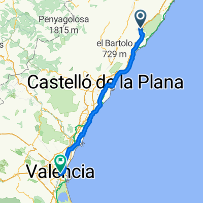
Start from the FCC station in Alcalá, a relaxed climb to the castle and a good track, descent to Santa Magdalena and a steep climb to the Castle (better to avoid the last ramp unless you want to go down to the castle itself of Sta. Magdalena), a couple of kilometers of technical trail to the hermitage of Sant Antoni, where you have to put your foot down, and then all downhill and flat to the Benicarló station.
- -:--
- Duration
- 38.9 km
- Distance
- 688 m
- Ascent
- 818 m
- Descent
- ---
- Avg. speed
- ---
- Max. altitude
Route quality
Waytypes & surfaces along the route
Waytypes
Track
22.2 km
(57 %)
Quiet road
7.8 km
(20 %)
Surfaces
Paved
16 km
(41 %)
Unpaved
15.6 km
(40 %)
Gravel
9.3 km
(24 %)
Asphalt
7.4 km
(19 %)
Continue with Bikemap
Use, edit, or download this cycling route
You would like to ride Castellets amb tren or customize it for your own trip? Here is what you can do with this Bikemap route:
Free features
- Save this route as favorite or in collections
- Copy & plan your own version of this route
- Sync your route with Garmin or Wahoo
Premium features
Free trial for 3 days, or one-time payment. More about Bikemap Premium.
- Navigate this route on iOS & Android
- Export a GPX / KML file of this route
- Create your custom printout (try it for free)
- Download this route for offline navigation
Discover more Premium features.
Get Bikemap PremiumFrom our community
Other popular routes starting in Alcalà de Xivert
 Carrer de Sant Mateu, Alcalà de Xivert nach Casa de Carabineros, Peñíscola
- Distance
- 18.8 km
- Ascent
- 211 m
- Descent
- 387 m
- Location
- Alcalà de Xivert, Valencia, Spain
 Castellets amb tren
- Distance
- 38.9 km
- Ascent
- 688 m
- Descent
- 818 m
- Location
- Alcalà de Xivert, Valencia, Spain
 Dag 24 Alcalà de Xivert, Spain - Valencia, Spain
- Distance
- 128.1 km
- Ascent
- 124 m
- Descent
- 269 m
- Location
- Alcalà de Xivert, Valencia, Spain
 Peñiscola 2
- Distance
- 68.5 km
- Ascent
- 1,214 m
- Descent
- 1,212 m
- Location
- Alcalà de Xivert, Valencia, Spain
 ALCALA-SERRATELLA-BANDERETA
- Distance
- 100.1 km
- Ascent
- 1,375 m
- Descent
- 1,372 m
- Location
- Alcalà de Xivert, Valencia, Spain
 Etapa 8
- Distance
- 149.8 km
- Ascent
- 286 m
- Descent
- 431 m
- Location
- Alcalà de Xivert, Valencia, Spain
 PUERTO DE CABANES
- Distance
- 75.6 km
- Ascent
- 847 m
- Descent
- 843 m
- Location
- Alcalà de Xivert, Valencia, Spain
 PÙERTO LA VALLTORTA- PUERTO LA SERRATELLA
- Distance
- 84.2 km
- Ascent
- 1,207 m
- Descent
- 1,206 m
- Location
- Alcalà de Xivert, Valencia, Spain
Open it in the app