

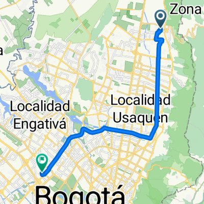
Paseo lento en Bogotá
A cycling route starting in La Calera, Cundinamarca, Colombia.
Overview
About this route
- 2 h 38 min
- Duration
- 35.5 km
- Distance
- 535 m
- Ascent
- 844 m
- Descent
- 13.5 km/h
- Avg. speed
- ---
- Max. altitude

Continue with Bikemap
Use, edit, or download this cycling route
You would like to ride Paseo lento en Bogotá or customize it for your own trip? Here is what you can do with this Bikemap route:
Free features
- Save this route as favorite or in collections
- Copy & plan your own version of this route
- Sync your route with Garmin or Wahoo
Premium features
Free trial for 3 days, or one-time payment. More about Bikemap Premium.
- Navigate this route on iOS & Android
- Export a GPX / KML file of this route
- Create your custom printout (try it for free)
- Download this route for offline navigation
Discover more Premium features.
Get Bikemap PremiumFrom our community
Other popular routes starting in La Calera
 Ruta GFNY
- Distance
- 137.4 km
- Ascent
- 1,821 m
- Descent
- 1,794 m
- Location
- La Calera, Cundinamarca, Colombia
 De Carrera 8d # 191-70 a Carrera 73a # 51A-29
- Distance
- 19.7 km
- Ascent
- 145 m
- Descent
- 162 m
- Location
- La Calera, Cundinamarca, Colombia
 San Luis, macadamia,San Luis.
- Distance
- 11.4 km
- Ascent
- 464 m
- Descent
- 99 m
- Location
- La Calera, Cundinamarca, Colombia
 Segunda Etapa
- Distance
- 84 km
- Ascent
- 893 m
- Descent
- 617 m
- Location
- La Calera, Cundinamarca, Colombia
 casa - la caro
- Distance
- 21 km
- Ascent
- 10 m
- Descent
- 12 m
- Location
- La Calera, Cundinamarca, Colombia
 la Calera, Guadalupe
- Distance
- 65.9 km
- Ascent
- 1,705 m
- Descent
- 1,706 m
- Location
- La Calera, Cundinamarca, Colombia
 kr 7ma -la calera
- Distance
- 16.9 km
- Ascent
- 436 m
- Descent
- 581 m
- Location
- La Calera, Cundinamarca, Colombia
 De Calle 181 51, Bogotá a Calle 181 8-60, Bogotá
- Distance
- 56.9 km
- Ascent
- 206 m
- Descent
- 283 m
- Location
- La Calera, Cundinamarca, Colombia
Open it in the app