

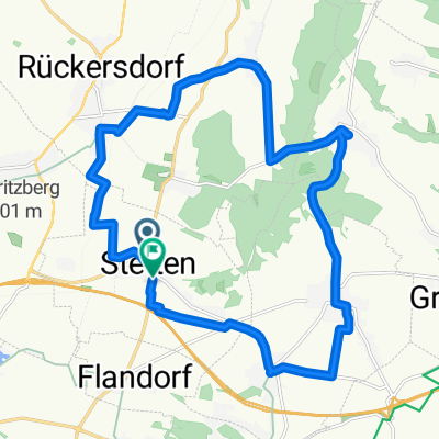
Weinviertel-Donau-Radtour
A cycling route starting in Stetten, Lower Austria, Austria.
Overview
About this route
- -:--
- Duration
- 39.1 km
- Distance
- 156 m
- Ascent
- 157 m
- Descent
- ---
- Avg. speed
- ---
- Max. altitude
Route quality
Waytypes & surfaces along the route
Waytypes
Track
11 km
(28 %)
Cycleway
10.6 km
(27 %)
Surfaces
Paved
31.3 km
(80 %)
Unpaved
4.7 km
(12 %)
Asphalt
30.1 km
(77 %)
Gravel
4.3 km
(11 %)
Continue with Bikemap
Use, edit, or download this cycling route
You would like to ride Weinviertel-Donau-Radtour or customize it for your own trip? Here is what you can do with this Bikemap route:
Free features
- Save this route as favorite or in collections
- Copy & plan your own version of this route
- Sync your route with Garmin or Wahoo
Premium features
Free trial for 3 days, or one-time payment. More about Bikemap Premium.
- Navigate this route on iOS & Android
- Export a GPX / KML file of this route
- Create your custom printout (try it for free)
- Download this route for offline navigation
Discover more Premium features.
Get Bikemap PremiumFrom our community
Other popular routes starting in Stetten
 Stetten-Sierndorf-Ernstbrunn-Stetten
- Distance
- 64.8 km
- Ascent
- 200 m
- Descent
- 124 m
- Location
- Stetten, Lower Austria, Austria
 Von Großebersdorf bis Laa an der Thaya
- Distance
- 61.1 km
- Ascent
- 610 m
- Descent
- 734 m
- Location
- Stetten, Lower Austria, Austria
 Stetten Experiment
- Distance
- 26.6 km
- Ascent
- 125 m
- Descent
- 128 m
- Location
- Stetten, Lower Austria, Austria
 Route zu Pfarre Stetten
- Distance
- 19.9 km
- Ascent
- 239 m
- Descent
- 240 m
- Location
- Stetten, Lower Austria, Austria
 highmaster highway
- Distance
- 65.7 km
- Ascent
- 267 m
- Descent
- 268 m
- Location
- Stetten, Lower Austria, Austria
 Stetten
- Distance
- 13.1 km
- Ascent
- 50 m
- Descent
- 62 m
- Location
- Stetten, Lower Austria, Austria
 Von Stetten bis Zeithain
- Distance
- 655.2 km
- Ascent
- 5,207 m
- Descent
- 5,294 m
- Location
- Stetten, Lower Austria, Austria
 4 Hügeln zum Abendessen
- Distance
- 34.3 km
- Ascent
- 370 m
- Descent
- 370 m
- Location
- Stetten, Lower Austria, Austria
Open it in the app