

Druga Čačul Biciklijada
A cycling route starting in Kutjevo, Požega-Slavonia County, Croatia.
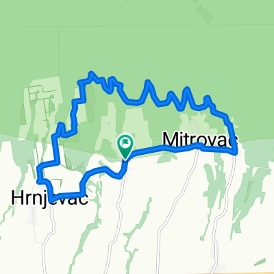
Overview
About this route
- -:--
- Duration
- 48.9 km
- Distance
- 342 m
- Ascent
- 737 m
- Descent
- ---
- Avg. speed
- ---
- Max. altitude

Route quality
Waytypes & surfaces along the route
Waytypes
Track
16.1 km
(33 %)
Quiet road
8.8 km
(18 %)
Surfaces
Paved
11.2 km
(23 %)
Unpaved
4.9 km
(10 %)
Asphalt
11.2 km
(23 %)
Gravel
4.4 km
(9 %)
Continue with Bikemap
Use, edit, or download this cycling route
You would like to ride Druga Čačul Biciklijada or customize it for your own trip? Here is what you can do with this Bikemap route:
Free features
- Save this route as favorite or in collections
- Copy & plan your own version of this route
- Sync your route with Garmin or Wahoo
Premium features
Free trial for 3 days, or one-time payment. More about Bikemap Premium.
- Navigate this route on iOS & Android
- Export a GPX / KML file of this route
- Create your custom printout (try it for free)
- Download this route for offline navigation
Discover more Premium features.
Get Bikemap PremiumFrom our community
Other popular routes starting in Kutjevo
 Od Papuka do obala Drave
- Distance
- 55.5 km
- Ascent
- 31 m
- Descent
- 532 m
- Location
- Kutjevo, Požega-Slavonia County, Croatia
 Prva Čaču Biciklijada
- Distance
- 69.6 km
- Ascent
- 665 m
- Descent
- 753 m
- Location
- Kutjevo, Požega-Slavonia County, Croatia
 Put graševine i pjesme
- Distance
- 21.8 km
- Ascent
- 220 m
- Descent
- 221 m
- Location
- Kutjevo, Požega-Slavonia County, Croatia
 Kutjevo
- Distance
- 40 km
- Ascent
- 761 m
- Descent
- 768 m
- Location
- Kutjevo, Požega-Slavonia County, Croatia
 18. Venje - Staza Lambrusca
- Distance
- 11.2 km
- Ascent
- 224 m
- Descent
- 226 m
- Location
- Kutjevo, Požega-Slavonia County, Croatia
 Oko Papuka verzija 1
- Distance
- 133.6 km
- Ascent
- 963 m
- Descent
- 964 m
- Location
- Kutjevo, Požega-Slavonia County, Croatia
 1. Kutjevo - Latinovac
- Distance
- 33.9 km
- Ascent
- 354 m
- Descent
- 352 m
- Location
- Kutjevo, Požega-Slavonia County, Croatia
 2. Kutjevo - Venje - Vetovo - Kaptol (ruta Grasevina)
- Distance
- 39 km
- Ascent
- 368 m
- Descent
- 368 m
- Location
- Kutjevo, Požega-Slavonia County, Croatia
Open it in the app