

Kocher-Jagst (2)
A cycling route starting in Aalen, Baden-Wurttemberg, Germany.
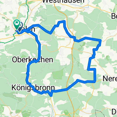
Overview
About this route
Down one river and back up the twin river, 333 kilometers of bike path with few climbs, mostly off-road through beautiful and varied landscape: this is unique! (Tour description at: thod_er@gmx.de)
- -:--
- Duration
- 337.1 km
- Distance
- 4,633 m
- Ascent
- 4,631 m
- Descent
- ---
- Avg. speed
- ---
- Max. altitude
Route quality
Waytypes & surfaces along the route
Waytypes
Track
138.2 km
(41 %)
Quiet road
64.1 km
(19 %)
Surfaces
Paved
296.7 km
(88 %)
Unpaved
6.7 km
(2 %)
Asphalt
259.6 km
(77 %)
Paved (undefined)
33.7 km
(10 %)
Continue with Bikemap
Use, edit, or download this cycling route
You would like to ride Kocher-Jagst (2) or customize it for your own trip? Here is what you can do with this Bikemap route:
Free features
- Save this route as favorite or in collections
- Copy & plan your own version of this route
- Split it into stages to create a multi-day tour
- Sync your route with Garmin or Wahoo
Premium features
Free trial for 3 days, or one-time payment. More about Bikemap Premium.
- Navigate this route on iOS & Android
- Export a GPX / KML file of this route
- Create your custom printout (try it for free)
- Download this route for offline navigation
Discover more Premium features.
Get Bikemap PremiumFrom our community
Other popular routes starting in Aalen
 Kocher-Jagst ab/bis Aalen
- Distance
- 333.4 km
- Ascent
- 682 m
- Descent
- 681 m
- Location
- Aalen, Baden-Wurttemberg, Germany
 Härtsfeldrunde
- Distance
- 62.3 km
- Ascent
- 596 m
- Descent
- 533 m
- Location
- Aalen, Baden-Wurttemberg, Germany
 Favourite Tracks IV
- Distance
- 19.6 km
- Ascent
- 450 m
- Descent
- 402 m
- Location
- Aalen, Baden-Wurttemberg, Germany
 2013-07-21 Andres Runde mit Kirschen
- Distance
- 58 km
- Ascent
- 435 m
- Descent
- 437 m
- Location
- Aalen, Baden-Wurttemberg, Germany
 Runde um Neuler
- Distance
- 45.8 km
- Ascent
- 792 m
- Descent
- 770 m
- Location
- Aalen, Baden-Wurttemberg, Germany
 Braunen Berg - Ipf - Baldern - Kapfenburg
- Distance
- 53.6 km
- Ascent
- 834 m
- Descent
- 834 m
- Location
- Aalen, Baden-Wurttemberg, Germany
 Kochertal Aalen - Schwäbisch Hall - Bad Friedrichsau Tag 1
- Distance
- 73.3 km
- Ascent
- 205 m
- Descent
- 369 m
- Location
- Aalen, Baden-Wurttemberg, Germany
 Remstalradroute
- Distance
- 72.6 km
- Ascent
- 3,847 m
- Descent
- 4,276 m
- Location
- Aalen, Baden-Wurttemberg, Germany
Open it in the app