
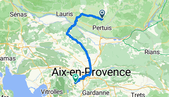
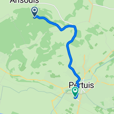
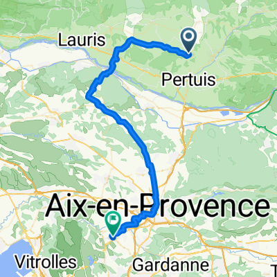
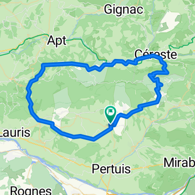
La tour d'aigues - Aix en prov.
A cycling route starting in Ansouis, Provence-Alpes-Côte d'Azur Region, France.
Overview
About this route
chic
- -:--
- Duration
- 55.4 km
- Distance
- 408 m
- Ascent
- 636 m
- Descent
- ---
- Avg. speed
- ---
- Max. altitude

Route quality
Waytypes & surfaces along the route
Waytypes
Road
27.7 km
(50 %)
Quiet road
16.6 km
(30 %)
Surfaces
Paved
28.8 km
(52 %)
Asphalt
28.2 km
(51 %)
Concrete
0.6 km
(1 %)
Undefined
26.6 km
(48 %)
Continue with Bikemap
Use, edit, or download this cycling route
You would like to ride La tour d'aigues - Aix en prov. or customize it for your own trip? Here is what you can do with this Bikemap route:
Free features
- Save this route as favorite or in collections
- Copy & plan your own version of this route
- Sync your route with Garmin or Wahoo
Premium features
Free trial for 3 days, or one-time payment. More about Bikemap Premium.
- Navigate this route on iOS & Android
- Export a GPX / KML file of this route
- Create your custom printout (try it for free)
- Download this route for offline navigation
Discover more Premium features.
Get Bikemap PremiumFrom our community
Other popular routes starting in Ansouis
 L etang to beaux de prov
- Distance
- 84.1 km
- Ascent
- 457 m
- Descent
- 743 m
- Location
- Ansouis, Provence-Alpes-Côte d'Azur Region, France
 Lange Radrunde nach Bennieux
- Distance
- 42.8 km
- Ascent
- 361 m
- Descent
- 363 m
- Location
- Ansouis, Provence-Alpes-Côte d'Azur Region, France
 Ansouis nach Aix-en-Provence
- Distance
- 49.1 km
- Ascent
- 855 m
- Descent
- 908 m
- Location
- Ansouis, Provence-Alpes-Côte d'Azur Region, France
 Ansouis Cucuron Loumarin Lauris cadenet und zurück
- Distance
- 44.9 km
- Ascent
- 240 m
- Descent
- 242 m
- Location
- Ansouis, Provence-Alpes-Côte d'Azur Region, France
 Vaug Vaug Lub horaire 70
- Distance
- 73 km
- Ascent
- 855 m
- Descent
- 851 m
- Location
- Ansouis, Provence-Alpes-Côte d'Azur Region, France
 De Chemin d'Ansouis aux Gavèdes, Ansouis à 39 Chemin des Moulins, Pertuis
- Distance
- 8.1 km
- Ascent
- 52 m
- Descent
- 223 m
- Location
- Ansouis, Provence-Alpes-Côte d'Azur Region, France
 La tour d'aigues - Aix en prov.
- Distance
- 55.4 km
- Ascent
- 408 m
- Descent
- 636 m
- Location
- Ansouis, Provence-Alpes-Côte d'Azur Region, France
 Provance 5. nap
- Distance
- 73.5 km
- Ascent
- 896 m
- Descent
- 896 m
- Location
- Ansouis, Provence-Alpes-Côte d'Azur Region, France
Open it in the app