

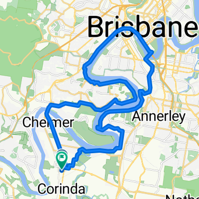
Southside Century
A cycling route starting in Rocklea, Queensland, Australia.
Overview
About this route
- -:--
- Duration
- 74.2 km
- Distance
- 257 m
- Ascent
- 256 m
- Descent
- ---
- Avg. speed
- ---
- Max. altitude
Route quality
Waytypes & surfaces along the route
Waytypes
Cycleway
34.9 km
(47 %)
Quiet road
17.1 km
(23 %)
Surfaces
Paved
72 km
(97 %)
Asphalt
40.1 km
(54 %)
Concrete
26.7 km
(36 %)
Route highlights
Points of interest along the route
Point of interest after 0.3 km
Continue with Bikemap
Use, edit, or download this cycling route
You would like to ride Southside Century or customize it for your own trip? Here is what you can do with this Bikemap route:
Free features
- Save this route as favorite or in collections
- Copy & plan your own version of this route
- Sync your route with Garmin or Wahoo
Premium features
Free trial for 3 days, or one-time payment. More about Bikemap Premium.
- Navigate this route on iOS & Android
- Export a GPX / KML file of this route
- Create your custom printout (try it for free)
- Download this route for offline navigation
Discover more Premium features.
Get Bikemap PremiumFrom our community
Other popular routes starting in Rocklea
 Sherwood - Greenbank Army Loop
- Distance
- 65.6 km
- Ascent
- 290 m
- Descent
- 290 m
- Location
- Rocklea, Queensland, Australia
 Sherwood-M3-River Loop
- Distance
- 59.2 km
- Ascent
- 245 m
- Descent
- 245 m
- Location
- Rocklea, Queensland, Australia
 507 Oxley Rd, Sherwood to 535 Oxley Rd, Sherwood
- Distance
- 33.7 km
- Ascent
- 286 m
- Descent
- 288 m
- Location
- Rocklea, Queensland, Australia
 Oxley Road 661, Corinda to William Street 35, Imbil
- Distance
- 165.5 km
- Ascent
- 2,690 m
- Descent
- 2,626 m
- Location
- Rocklea, Queensland, Australia
 Primrose St, Sherwood to Primrose St, Sherwood
- Distance
- 31.6 km
- Ascent
- 266 m
- Descent
- 267 m
- Location
- Rocklea, Queensland, Australia
 Paseo intenso en Oxley
- Distance
- 51.8 km
- Ascent
- 1,351 m
- Descent
- 1,335 m
- Location
- Rocklea, Queensland, Australia
 River Loop
- Distance
- 35.2 km
- Ascent
- 154 m
- Descent
- 154 m
- Location
- Rocklea, Queensland, Australia
 Graceville-Seventeen Mile Rocks-Toowong loop
- Distance
- 37.1 km
- Ascent
- 224 m
- Descent
- 222 m
- Location
- Rocklea, Queensland, Australia
Open it in the app