

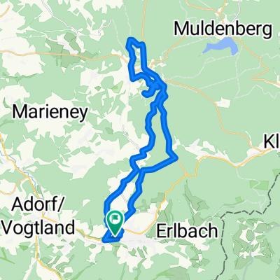
Breitenfeld-Hoher Stein-Landwüst-Raun-Bad Elster-Adorf-Wohlbach
A cycling route starting in Markneukirchen, Saxony, Germany.
Overview
About this route
- -:--
- Duration
- 46.6 km
- Distance
- 716 m
- Ascent
- 716 m
- Descent
- ---
- Avg. speed
- ---
- Max. altitude

Continue with Bikemap
Use, edit, or download this cycling route
You would like to ride Breitenfeld-Hoher Stein-Landwüst-Raun-Bad Elster-Adorf-Wohlbach or customize it for your own trip? Here is what you can do with this Bikemap route:
Free features
- Save this route as favorite or in collections
- Copy & plan your own version of this route
- Sync your route with Garmin or Wahoo
Premium features
Free trial for 3 days, or one-time payment. More about Bikemap Premium.
- Navigate this route on iOS & Android
- Export a GPX / KML file of this route
- Create your custom printout (try it for free)
- Download this route for offline navigation
Discover more Premium features.
Get Bikemap PremiumFrom our community
Other popular routes starting in Markneukirchen
 Markneukirchen-Loket
- Distance
- 43.8 km
- Ascent
- 604 m
- Descent
- 685 m
- Location
- Markneukirchen, Saxony, Germany
 20150809_162954.gpx
- Distance
- 34.9 km
- Ascent
- 581 m
- Descent
- 580 m
- Location
- Markneukirchen, Saxony, Germany
 schöneck
- Distance
- 16 km
- Ascent
- 704 m
- Descent
- 603 m
- Location
- Markneukirchen, Saxony, Germany
 MNK-Klingenthal-Johanngeorgenstadt-Auerbach-MNK
- Distance
- 128.2 km
- Ascent
- 1,680 m
- Descent
- 1,680 m
- Location
- Markneukirchen, Saxony, Germany
 Blistering ride in Schöneck/Vogtland
- Distance
- 16.8 km
- Ascent
- 459 m
- Descent
- 534 m
- Location
- Markneukirchen, Saxony, Germany
 Nach Hause mit dem Rad
- Distance
- 360 km
- Ascent
- 3,469 m
- Descent
- 3,590 m
- Location
- Markneukirchen, Saxony, Germany
 Markneukirchen 100km
- Distance
- 104.6 km
- Ascent
- 1,195 m
- Descent
- 1,173 m
- Location
- Markneukirchen, Saxony, Germany
 Markneukirchen- Prag
- Distance
- 187.5 km
- Ascent
- 1,110 m
- Descent
- 1,356 m
- Location
- Markneukirchen, Saxony, Germany
Open it in the app