


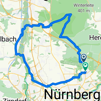
Teilstück Nürnberger Gravel Tour von Ziegelstein über Tennenlohe, Solarberg zurück
- 41.1 km
- 320 m
- 375 m
- Nuremberg, Bavaria, Germany
A cycling route starting in Nuremberg, Bavaria, Germany.
Overview
The route was ridden by me and recorded with a Garmin Oregon 300. This tour will start on August 21, 2010, at Tiergarten Nuremberg. The second meeting point is a few kilometers further at Valznerweiher (parking lot opposite the FCN grounds). Occasion: As a so-called 'Radpatentour' in collaboration between Forum Radfahren and ADFC Nuremberg to make the homeland accessible to the citizens. The tour is about 60 km, mostly flat, and therefore family-friendly. Mostly on quiet side roads and gravel paths, this tour is suitable for all types of bicycles except racing bikes. A simple gear setup is sufficient.
created this 15 years ago
Route quality
Track
24.6 km
(43 %)
Quiet road
14.9 km
(26 %)
Paved
29.7 km
(52 %)
Unpaved
24 km
(42 %)
Asphalt
28 km
(49 %)
Gravel
20.6 km
(36 %)
Route highlights

Das ehemalige Birgittenkloster

Pause in Gnadenberg Gasthof zum Kloster

Diese Wegweisung scheint doch schon etwas älter zu sein..............
Continue with Bikemap
You would like to ride Nürnberg Süd -Ost or customize it for your own trip? Here is what you can do with this Bikemap route:
Free trial for 3 days, or one-time payment. More about Bikemap Premium.
Discover more Premium features.
Get Bikemap PremiumFrom our community
Open it in the app


