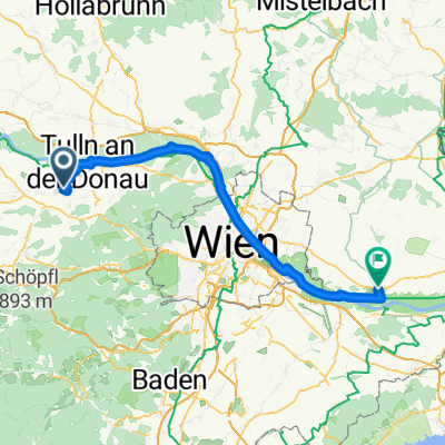
Tulln Hotel Tullnerfeld, - Obersdorf
A cycling route starting in Langenrohr, Lower Austria, Austria.
Overview
About this route
- -:--
- Duration
- 44.6 km
- Distance
- 156 m
- Ascent
- 160 m
- Descent
- ---
- Avg. speed
- 228 m
- Avg. speed
Route quality
Waytypes & surfaces along the route
Waytypes
Track
17.2 km
(39 %)
Cycleway
14.8 km
(33 %)
Surfaces
Paved
41.1 km
(92 %)
Unpaved
0.4 km
(<1 %)
Asphalt
40.1 km
(90 %)
Wood
0.5 km
(1 %)
Continue with Bikemap
Use, edit, or download this cycling route
You would like to ride Tulln Hotel Tullnerfeld, - Obersdorf or customize it for your own trip? Here is what you can do with this Bikemap route:
Free features
- Save this route as favorite or in collections
- Copy & plan your own version of this route
- Sync your route with Garmin or Wahoo
Premium features
Free trial for 3 days, or one-time payment. More about Bikemap Premium.
- Navigate this route on iOS & Android
- Export a GPX / KML file of this route
- Create your custom printout (try it for free)
- Download this route for offline navigation
Discover more Premium features.
Get Bikemap PremiumFrom our community
Other popular routes starting in Langenrohr
- Überländstraße, Langenrohr nach Gartenweg, Neusiedl am See
- Distance
- 103.9 km
- Ascent
- 434 m
- Descent
- 493 m
- Location
- Langenrohr, Lower Austria, Austria
- Tulln bis Rust
- Distance
- 121.2 km
- Ascent
- 541 m
- Descent
- 594 m
- Location
- Langenrohr, Lower Austria, Austria
- Tulln Hotel Tullnerfeld, - Obersdorf
- Distance
- 44.6 km
- Ascent
- 156 m
- Descent
- 160 m
- Location
- Langenrohr, Lower Austria, Austria
- Langenrohr-Mariazell-Langenrohr
- Distance
- 238.6 km
- Ascent
- 3,312 m
- Descent
- 3,174 m
- Location
- Langenrohr, Lower Austria, Austria
- L2090 to Hauptallee W, Wien
- Distance
- 48.7 km
- Ascent
- 90 m
- Descent
- 173 m
- Location
- Langenrohr, Lower Austria, Austria
- Z03 Tulln - Krems
- Distance
- 76.7 km
- Ascent
- 228 m
- Descent
- 206 m
- Location
- Langenrohr, Lower Austria, Austria
- Pixendorfer Familyrundweg
- Distance
- 25.6 km
- Ascent
- 33 m
- Descent
- 33 m
- Location
- Langenrohr, Lower Austria, Austria
- Laabental Radweg
- Distance
- 33.6 km
- Ascent
- 234 m
- Descent
- 58 m
- Location
- Langenrohr, Lower Austria, Austria
Open it in the app