

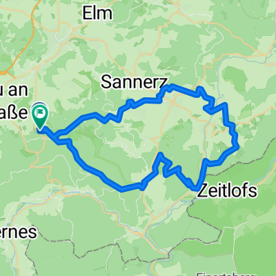
BW-Giro Tour 151km
A cycling route starting in Steinau an der Straße, Hesse, Germany.
Overview
About this route
The longest route of our spring ride through Rhön, Spessart and Vogelsberg. Feeding Check 1 after 20 km at Sterbfritz station. Followed by a Flying Control (water, stamp) at km 28 in Oberzell. Feeding K2 at km 49 in Marjoß-Barackenhöfe, Feeding K3 in Schlierbach (km 80), water and tea station in Ulmbach (km 96), Feeding K4 in Breitenbach (km 111) and a Flying Control (water, tea and stamp) at km 135. Demanding tour for well-trained riders! Start time limited to 8 to 9:30 am. Control closure around 4 pm.
- -:--
- Duration
- 154.5 km
- Distance
- 1,209 m
- Ascent
- 1,210 m
- Descent
- ---
- Avg. speed
- ---
- Max. altitude

Route quality
Waytypes & surfaces along the route
Waytypes
Road
37.1 km
(24 %)
Quiet road
10.8 km
(7 %)
Surfaces
Paved
134.4 km
(87 %)
Asphalt
132.8 km
(86 %)
Paved (undefined)
1.5 km
(1 %)
Undefined
20.1 km
(13 %)
Continue with Bikemap
Use, edit, or download this cycling route
You would like to ride BW-Giro Tour 151km or customize it for your own trip? Here is what you can do with this Bikemap route:
Free features
- Save this route as favorite or in collections
- Copy & plan your own version of this route
- Split it into stages to create a multi-day tour
- Sync your route with Garmin or Wahoo
Premium features
Free trial for 3 days, or one-time payment. More about Bikemap Premium.
- Navigate this route on iOS & Android
- Export a GPX / KML file of this route
- Create your custom printout (try it for free)
- Download this route for offline navigation
Discover more Premium features.
Get Bikemap PremiumFrom our community
Other popular routes starting in Steinau an der Straße
 Route 2 in Steinau an der Straße
- Distance
- 42.2 km
- Ascent
- 1,040 m
- Descent
- 1,039 m
- Location
- Steinau an der Straße, Hesse, Germany
 Hessische Saisoneröffnung RTF -Große Tour
- Distance
- 76.9 km
- Ascent
- 197 m
- Descent
- 191 m
- Location
- Steinau an der Straße, Hesse, Germany
 Hessische Saisoneröffnung RTF -KleineTour ab Steinau
- Distance
- 42.4 km
- Ascent
- 185 m
- Descent
- 185 m
- Location
- Steinau an der Straße, Hesse, Germany
 Hohenzeller Weg 4A, Steinau an der Straße nach Spessartstraße 28, Sinntal
- Distance
- 14.2 km
- Ascent
- 269 m
- Descent
- 306 m
- Location
- Steinau an der Straße, Hesse, Germany
 Gerade Fahrt in Bad Soden-Salmünster
- Distance
- 14.7 km
- Ascent
- 58 m
- Descent
- 25 m
- Location
- Steinau an der Straße, Hesse, Germany
 От Steinauer Straße до Steinauer Straße
- Distance
- 30.3 km
- Ascent
- 275 m
- Descent
- 320 m
- Location
- Steinau an der Straße, Hesse, Germany
 CTF Fahrt in den Mai 20 km
- Distance
- 20.5 km
- Ascent
- 415 m
- Descent
- 412 m
- Location
- Steinau an der Straße, Hesse, Germany
 Steinau an der Strasse - Lohr am Main
- Distance
- 74.5 km
- Ascent
- 376 m
- Descent
- 388 m
- Location
- Steinau an der Straße, Hesse, Germany
Open it in the app