- 36.7 km
- 152 m
- 145 m
- Mendota Heights, Minnesota, United States
B2B 55116 > 55106 via Summit Ave, Kellogg Blvd E
A cycling route starting in Mendota Heights, Minnesota, United States.
Overview
About this route
This route will include quite a lot of street riding. Kellogg is far superior to 7th St, as traffic is much more tolerant of cyclists on the wider lanes of Kellogg. Summit provides an excellent early-morning ride. ~9 mi each way
- -:--
- Duration
- 14.3 km
- Distance
- 40 m
- Ascent
- 63 m
- Descent
- ---
- Avg. speed
- 285 m
- Max. altitude
Route quality
Waytypes & surfaces along the route
Waytypes
Road
6.1 km
(43 %)
Quiet road
3.3 km
(23 %)
Surfaces
Paved
8.2 km
(57 %)
Asphalt
7.4 km
(52 %)
Concrete
0.6 km
(4 %)
Route highlights
Points of interest along the route
Point of interest after 1.8 km
Summit Ave has a great bike lane all the way to downtown.
Continue with Bikemap
Use, edit, or download this cycling route
You would like to ride B2B 55116 > 55106 via Summit Ave, Kellogg Blvd E or customize it for your own trip? Here is what you can do with this Bikemap route:
Free features
- Save this route as favorite or in collections
- Copy & plan your own version of this route
- Sync your route with Garmin or Wahoo
Premium features
Free trial for 3 days, or one-time payment. More about Bikemap Premium.
- Navigate this route on iOS & Android
- Export a GPX / KML file of this route
- Create your custom printout (try it for free)
- Download this route for offline navigation
Discover more Premium features.
Get Bikemap PremiumFrom our community
Other popular routes starting in Mendota Heights
- Mississippi River Boulevard South 615-645 to Mississippi River Boulevard South 615-645
- Mendota to Calhoun
- 22 km
- 171 m
- 132 m
- Mendota Heights, Minnesota, United States
- Northfield
- 72.1 km
- 472 m
- 450 m
- Mendota Heights, Minnesota, United States
- B2B 55116 > 55106 via Summit Ave, Kellogg Blvd E
- 14.3 km
- 40 m
- 63 m
- Mendota Heights, Minnesota, United States
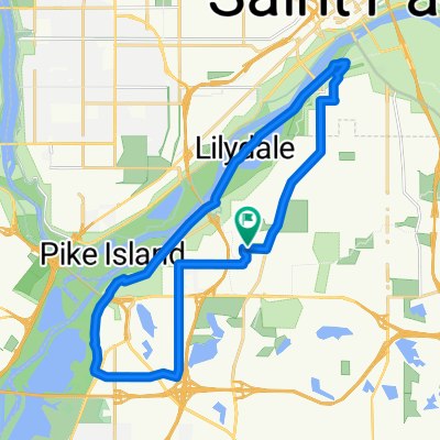
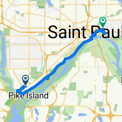
- Mostly flat Twin Cities trails ride
- 48.2 km
- 176 m
- 176 m
- Mendota Heights, Minnesota, United States
- Wandering Leaf to Yoerg
- 15.4 km
- 134 m
- 129 m
- Mendota Heights, Minnesota, United States
- Snail-like route in Mendota Heights
- 14 km
- 325 m
- 325 m
- Mendota Heights, Minnesota, United States
- The Origin
- 28 km
- 173 m
- 174 m
- Mendota Heights, Minnesota, United States
Open it in the app


