

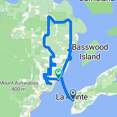
Washburn-Cornicopa-Bayfield Loop
A cycling route starting in Washburn, Wisconsin, United States.
Overview
About this route
- -:--
- Duration
- 83.8 km
- Distance
- 590 m
- Ascent
- 592 m
- Descent
- ---
- Avg. speed
- ---
- Max. altitude

Route quality
Waytypes & surfaces along the route
Waytypes
Quiet road
12.6 km
(15 %)
Road
3.4 km
(4 %)
Surfaces
Paved
76.3 km
(91 %)
Unpaved
0.8 km
(1 %)
Asphalt
72.9 km
(87 %)
Paved (undefined)
3.4 km
(4 %)
Continue with Bikemap
Use, edit, or download this cycling route
You would like to ride Washburn-Cornicopa-Bayfield Loop or customize it for your own trip? Here is what you can do with this Bikemap route:
Free features
- Save this route as favorite or in collections
- Copy & plan your own version of this route
- Split it into stages to create a multi-day tour
- Sync your route with Garmin or Wahoo
Premium features
Free trial for 3 days, or one-time payment. More about Bikemap Premium.
- Navigate this route on iOS & Android
- Export a GPX / KML file of this route
- Create your custom printout (try it for free)
- Download this route for offline navigation
Discover more Premium features.
Get Bikemap PremiumFrom our community
Other popular routes starting in Washburn
 day_6
day_6- Distance
- 106.7 km
- Ascent
- 591 m
- Descent
- 347 m
- Location
- Washburn, Wisconsin, United States
 Route to 20 Washington Ave, Bayfield
- Distance
- 3.2 km
- Ascent
- 11 m
- Descent
- 11 m
- Location
- Washburn, Wisconsin, United States
 Main St, La Pointe to Wilson Ave, Bayfield
- Distance
- 52.1 km
- Ascent
- 663 m
- Descent
- 659 m
- Location
- Washburn, Wisconsin, United States
 Robert and Patricia ride to Long Lake and to the campground and back Washburn
- Distance
- 27.2 km
- Ascent
- 237 m
- Descent
- 235 m
- Location
- Washburn, Wisconsin, United States
 30 N Broad St, Bayfield to 950 CTH-C, Washburn
- Distance
- 47.4 km
- Ascent
- 558 m
- Descent
- 516 m
- Location
- Washburn, Wisconsin, United States
 Washburn-Cornicopa-Bayfield Loop
- Distance
- 83.8 km
- Ascent
- 590 m
- Descent
- 592 m
- Location
- Washburn, Wisconsin, United States
 Pine Barrens/Washburn Road Bike Route
- Distance
- 82.5 km
- Ascent
- 342 m
- Descent
- 326 m
- Location
- Washburn, Wisconsin, United States
 day_5
day_5- Distance
- 19.4 km
- Ascent
- 136 m
- Descent
- 160 m
- Location
- Washburn, Wisconsin, United States
Open it in the app