
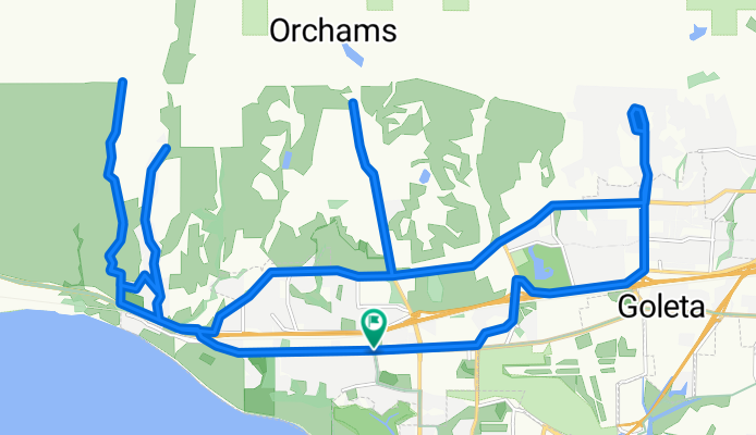
Mountain approaches in West Goleta
A cycling route starting in Isla Vista, California, United States.
Overview
About this route
This route includes all the major publicly accessible mountain-bound dead-end roads in West Goleta. The easternmost and westernmost ones (Fairview Rd and Farren Rd) involve climbing, but the rest of the route is relatively flat. Cathedral Oaks Rd, Glen Annie Rd, and Vereda Del Ciervo are particularly well suited for time-trial practice (few to no traffic lights, gradual elevation changes, little traffic or wide shoulder).
- -:--
- Duration
- 42.3 km
- Distance
- 376 m
- Ascent
- 374 m
- Descent
- ---
- Avg. speed
- ---
- Max. altitude
Route quality
Waytypes & surfaces along the route
Waytypes
Quiet road
21.6 km
(51 %)
Road
5.5 km
(13 %)
Surfaces
Paved
11.4 km
(27 %)
Unpaved
0.4 km
(1 %)
Paved (undefined)
7.2 km
(17 %)
Asphalt
4.2 km
(10 %)
Continue with Bikemap
Use, edit, or download this cycling route
You would like to ride Mountain approaches in West Goleta or customize it for your own trip? Here is what you can do with this Bikemap route:
Free features
- Save this route as favorite or in collections
- Copy & plan your own version of this route
- Sync your route with Garmin or Wahoo
Premium features
Free trial for 3 days, or one-time payment. More about Bikemap Premium.
- Navigate this route on iOS & Android
- Export a GPX / KML file of this route
- Create your custom printout (try it for free)
- Download this route for offline navigation
Discover more Premium features.
Get Bikemap PremiumFrom our community
Other popular routes starting in Isla Vista
 Isla Vista to East Beach
- Distance
- 27.4 km
- Ascent
- 207 m
- Descent
- 215 m
- Location
- Isla Vista, California, United States
 Gibraltar and Painted Caves and OSM Ridge Route CLONED FROM ROUTE 1427172 CLONED FROM ROUTE 1849838
- Distance
- 70.6 km
- Ascent
- 1,329 m
- Descent
- 1,329 m
- Location
- Isla Vista, California, United States
 UCSB to SB
- Distance
- 15.8 km
- Ascent
- 116 m
- Descent
- 99 m
- Location
- Isla Vista, California, United States
 embarc —> hssb
- Distance
- 0.8 km
- Ascent
- 0 m
- Descent
- 0 m
- Location
- Isla Vista, California, United States
 Goleta to Santa Barbara with a San Marcos Rd detour
- Distance
- 37.3 km
- Ascent
- 646 m
- Descent
- 633 m
- Location
- Isla Vista, California, United States
 Cat Oaks
- Distance
- 26.3 km
- Ascent
- 103 m
- Descent
- 103 m
- Location
- Isla Vista, California, United States
 Mountain approaches in West Goleta
- Distance
- 42.3 km
- Ascent
- 376 m
- Descent
- 374 m
- Location
- Isla Vista, California, United States
 Painted Cave, up only
- Distance
- 20.9 km
- Ascent
- 868 m
- Descent
- 35 m
- Location
- Isla Vista, California, United States
Open it in the app