

RI MS 150 2010 Day 1
A cycling route starting in Narragansett Pier, Rhode Island, United States.
Overview
About this route
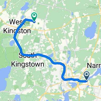
Preliminary route of Rhode Island MS 150, day one.
- -:--
- Duration
- 127.1 km
- Distance
- 472 m
- Ascent
- 428 m
- Descent
- ---
- Avg. speed
- ---
- Max. altitude
Route quality
Waytypes & surfaces along the route
Waytypes
Road
47 km
(37 %)
Quiet road
36.9 km
(29 %)
Surfaces
Paved
47 km
(37 %)
Asphalt
25.4 km
(20 %)
Paved (undefined)
20.3 km
(16 %)
Route highlights
Points of interest along the route
Point of interest after 22.7 km
Rest stop #1
Point of interest after 49.7 km
Rest stop #2
Point of interest after 70.7 km
Rest stop #3
Point of interest after 89.3 km
Rest stop #4 - North Stonington FD
Point of interest after 111 km
Rest stop #5 - Old Mystic Baptist Church
Point of interest after 127.1 km
End of Day 1
Continue with Bikemap
Use, edit, or download this cycling route
You would like to ride RI MS 150 2010 Day 1 or customize it for your own trip? Here is what you can do with this Bikemap route:
Free features
- Save this route as favorite or in collections
- Copy & plan your own version of this route
- Split it into stages to create a multi-day tour
- Sync your route with Garmin or Wahoo
Premium features
Free trial for 3 days, or one-time payment. More about Bikemap Premium.
- Navigate this route on iOS & Android
- Export a GPX / KML file of this route
- Create your custom printout (try it for free)
- Download this route for offline navigation
Discover more Premium features.
Get Bikemap PremiumFrom our community
Other popular routes starting in Narragansett Pier
 Moderate route in Kingston
- Distance
- 12.7 km
- Ascent
- 86 m
- Descent
- 41 m
- Location
- Narragansett Pier, Rhode Island, United States
 56 Boon St, Narragansett to 2–10 Kingstown Rd, Narragansett
- Distance
- 20.9 km
- Ascent
- 74 m
- Descent
- 131 m
- Location
- Narragansett Pier, Rhode Island, United States
 Tour trial run
- Distance
- 42.5 km
- Ascent
- 204 m
- Descent
- 204 m
- Location
- Narragansett Pier, Rhode Island, United States
 720 Middlebridge Rd, Wakefield to 720 Middlebridge Rd, Wakefield
- Distance
- 17.6 km
- Ascent
- 10 m
- Descent
- 17 m
- Location
- Narragansett Pier, Rhode Island, United States
 39 Boston Neck Rd, Narragansett to 350 Columbia St, Wakefield
- Distance
- 5.8 km
- Ascent
- 43 m
- Descent
- 38 m
- Location
- Narragansett Pier, Rhode Island, United States
 39 Boston Neck Rd, Narragansett to 63–81 Ocean Rd, Narragansett
- Distance
- 24.6 km
- Ascent
- 69 m
- Descent
- 66 m
- Location
- Narragansett Pier, Rhode Island, United States
 1 Beach St, Narragansett to 168 Sand Hill Cove Rd, Narragansett
- Distance
- 11.4 km
- Ascent
- 34 m
- Descent
- 34 m
- Location
- Narragansett Pier, Rhode Island, United States
 25 miles W C. O'Neill Bike Path Narragansett
- Distance
- 40.9 km
- Ascent
- 490 m
- Descent
- 483 m
- Location
- Narragansett Pier, Rhode Island, United States
Open it in the app