

Col de La Forclaz (and above)
A cycling route starting in Annecy, Auvergne-Rhône-Alpes, France.
Overview
About this route
Lake Annecy loop via the bike path on west side and then Col de la Forclaz on the east. Plus a small detour above the Col for better lake views at the Parapent take-off site.
- -:--
- Duration
- 52 km
- Distance
- 972 m
- Ascent
- 954 m
- Descent
- ---
- Avg. speed
- ---
- Max. altitude

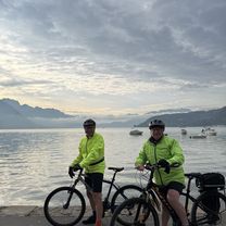
Route photos
\"")
\"")
\"")
\"")
Route quality
Waytypes & surfaces along the route
Waytypes
Cycleway
22.4 km
(43 %)
Road
15.6 km
(30 %)
Surfaces
Paved
47.3 km
(91 %)
Unpaved
1 km
(2 %)
Asphalt
46.8 km
(90 %)
Concrete
0.5 km
(1 %)
Continue with Bikemap
Use, edit, or download this cycling route
You would like to ride Col de La Forclaz (and above) or customize it for your own trip? Here is what you can do with this Bikemap route:
Free features
- Save this route as favorite or in collections
- Copy & plan your own version of this route
- Sync your route with Garmin or Wahoo
Premium features
Free trial for 3 days, or one-time payment. More about Bikemap Premium.
- Navigate this route on iOS & Android
- Export a GPX / KML file of this route
- Create your custom printout (try it for free)
- Download this route for offline navigation
Discover more Premium features.
Get Bikemap PremiumFrom our community
Other popular routes starting in Annecy
 Tour of Lake Annecy
- Distance
- 39.9 km
- Ascent
- 320 m
- Descent
- 329 m
- Location
- Annecy, Auvergne-Rhône-Alpes, France
 Annecy - Pontcharra
- Distance
- 92.5 km
- Ascent
- 278 m
- Descent
- 475 m
- Location
- Annecy, Auvergne-Rhône-Alpes, France
 Annecy to Bormio
- Distance
- 732.2 km
- Ascent
- 9,503 m
- Descent
- 8,752 m
- Location
- Annecy, Auvergne-Rhône-Alpes, France
 02 Rund um den Lac d'Annecy
- Distance
- 40.3 km
- Ascent
- 350 m
- Descent
- 346 m
- Location
- Annecy, Auvergne-Rhône-Alpes, France
 Route in Annecy
- Distance
- 39.3 km
- Ascent
- 345 m
- Descent
- 347 m
- Location
- Annecy, Auvergne-Rhône-Alpes, France
 Annecy lake round
- Distance
- 37.5 km
- Ascent
- 343 m
- Descent
- 343 m
- Location
- Annecy, Auvergne-Rhône-Alpes, France
 FORCLAZ MONTMIN VERSANT SUD 31MAI 2014
- Distance
- 54.5 km
- Ascent
- 757 m
- Descent
- 759 m
- Location
- Annecy, Auvergne-Rhône-Alpes, France
 Day 1 - Annecy to Montgilbert
- Distance
- 60.9 km
- Ascent
- 767 m
- Descent
- 678 m
- Location
- Annecy, Auvergne-Rhône-Alpes, France
Open it in the app