

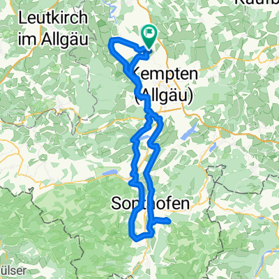
Tagestour entlang der Allgäuer Alpen
A cycling route starting in Lauben, Bavaria, Germany.
Overview
About this route
The route starts in the northern Oberallgäu - at the edge of Westallgäu towards Austria - from there through the traffic-free Rohrmoos into the Kleinwalsertal/Oberstdorf mountain landscape - along the low-traffic Illertal to Sonthofen, then to Immenstadt on the old triathlon route and leaving it above Niedersonthofen towards Kempten - via Ahegg, Ermengerst, Wiggensbach and from there back to the starting point through Hohenrad and Depsried. Varied combinations possible.
- -:--
- Duration
- 164.9 km
- Distance
- 1,064 m
- Ascent
- 1,060 m
- Descent
- ---
- Avg. speed
- ---
- Max. altitude

Route quality
Waytypes & surfaces along the route
Waytypes
Quiet road
69.3 km
(42 %)
Road
46.2 km
(28 %)
Surfaces
Paved
140.2 km
(85 %)
Unpaved
1.6 km
(1 %)
Asphalt
138.5 km
(84 %)
Paved (undefined)
1.6 km
(1 %)
Continue with Bikemap
Use, edit, or download this cycling route
You would like to ride Tagestour entlang der Allgäuer Alpen or customize it for your own trip? Here is what you can do with this Bikemap route:
Free features
- Save this route as favorite or in collections
- Copy & plan your own version of this route
- Split it into stages to create a multi-day tour
- Sync your route with Garmin or Wahoo
Premium features
Free trial for 3 days, or one-time payment. More about Bikemap Premium.
- Navigate this route on iOS & Android
- Export a GPX / KML file of this route
- Create your custom printout (try it for free)
- Download this route for offline navigation
Discover more Premium features.
Get Bikemap PremiumFrom our community
Other popular routes starting in Lauben
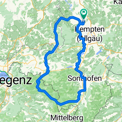
 Krugzell - Sonthofener Hof
- Distance
- 124.6 km
- Ascent
- 1,003 m
- Descent
- 1,003 m
- Location
- Lauben, Bavaria, Germany
 Tagestour entlang der Allgäuer Alpen
- Distance
- 164.9 km
- Ascent
- 1,064 m
- Descent
- 1,060 m
- Location
- Lauben, Bavaria, Germany
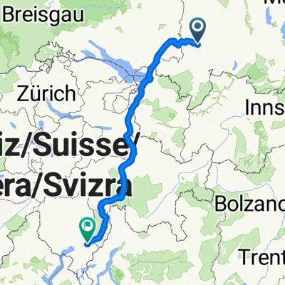 san Bernardino
- Distance
- 301.7 km
- Ascent
- 4,739 m
- Descent
- 5,181 m
- Location
- Lauben, Bavaria, Germany
 Rund um Kempten
- Distance
- 107.4 km
- Ascent
- 894 m
- Descent
- 894 m
- Location
- Lauben, Bavaria, Germany
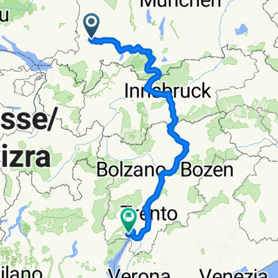 Tulpenweg, Lauben nach Piazza Catena, Riva del Garda
- Distance
- 458.5 km
- Ascent
- 6,592 m
- Descent
- 7,189 m
- Location
- Lauben, Bavaria, Germany
 Hochgratweg 24, Lauben nach Hochgratweg 20, Lauben
- Distance
- 48.7 km
- Ascent
- 1,820 m
- Descent
- 1,822 m
- Location
- Lauben, Bavaria, Germany
 Wild West ride out - small version
- Distance
- 9.9 km
- Ascent
- 86 m
- Descent
- 86 m
- Location
- Lauben, Bavaria, Germany
 Krugzell - Bregenzer Wald - Bodensee
- Distance
- 117.5 km
- Ascent
- 1,184 m
- Descent
- 1,447 m
- Location
- Lauben, Bavaria, Germany
Open it in the app