

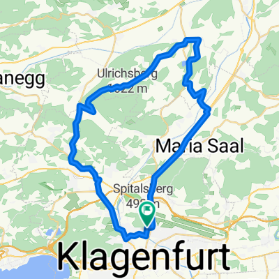
MTB-Berg: KLU - Pirkerkogel
A cycling route starting in Klagenfurt, Carinthia, Austria.
Overview
About this route
MTB-Berg: KLU - Pirkerkogel
- -:--
- Duration
- 9.2 km
- Distance
- 228 m
- Ascent
- 9 m
- Descent
- ---
- Avg. speed
- ---
- Avg. speed

Route quality
Waytypes & surfaces along the route
Waytypes
Quiet road
5.3 km
(58 %)
Path
1.2 km
(13 %)
Surfaces
Paved
6.7 km
(72 %)
Unpaved
1.9 km
(20 %)
Asphalt
6.4 km
(69 %)
Ground
1.7 km
(18 %)
Continue with Bikemap
Use, edit, or download this cycling route
You would like to ride MTB-Berg: KLU - Pirkerkogel or customize it for your own trip? Here is what you can do with this Bikemap route:
Free features
- Save this route as favorite or in collections
- Copy & plan your own version of this route
- Sync your route with Garmin or Wahoo
Premium features
Free trial for 3 days, or one-time payment. More about Bikemap Premium.
- Navigate this route on iOS & Android
- Export a GPX / KML file of this route
- Create your custom printout (try it for free)
- Download this route for offline navigation
Discover more Premium features.
Get Bikemap PremiumFrom our community
Other popular routes starting in Klagenfurt
 IRONMAN Austria (2006 - dato)
- Distance
- 89.4 km
- Ascent
- 1,188 m
- Descent
- 1,135 m
- Location
- Klagenfurt, Carinthia, Austria
 Unterkärnten extreme
- Distance
- 127.9 km
- Ascent
- 2,804 m
- Descent
- 2,780 m
- Location
- Klagenfurt, Carinthia, Austria
 Klagenfurt I
- Distance
- 29.4 km
- Ascent
- 65 m
- Descent
- 61 m
- Location
- Klagenfurt, Carinthia, Austria
 Wilsonstraße 71, Klagenfurt am Wörthersee do Wilsonstraße 71, Klagenfurt am Wörthersee
- Distance
- 40.7 km
- Ascent
- 559 m
- Descent
- 561 m
- Location
- Klagenfurt, Carinthia, Austria
 Ostersonntag
- Distance
- 75.2 km
- Ascent
- 388 m
- Descent
- 389 m
- Location
- Klagenfurt, Carinthia, Austria
 Hörzendorf Runde
- Distance
- 34.8 km
- Ascent
- 536 m
- Descent
- 542 m
- Location
- Klagenfurt, Carinthia, Austria
 9 Seenrunde Klagenfurt-Klagenfurt
- Distance
- 62.8 km
- Ascent
- 754 m
- Descent
- 753 m
- Location
- Klagenfurt, Carinthia, Austria
 Klagenfurt Nord- Dürnstein
- Distance
- 34 km
- Ascent
- 234 m
- Descent
- 92 m
- Location
- Klagenfurt, Carinthia, Austria
Open it in the app