

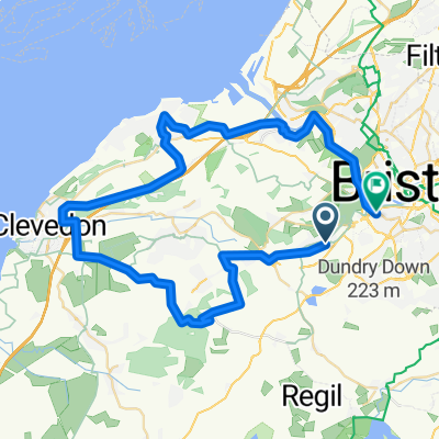
Chew valley short
A cycling route starting in Long Ashton, England, United Kingdom.
Overview
About this route
- -:--
- Duration
- 33.2 km
- Distance
- 297 m
- Ascent
- 305 m
- Descent
- ---
- Avg. speed
- ---
- Max. altitude
Route quality
Waytypes & surfaces along the route
Waytypes
Quiet road
19.9 km
(60 %)
Cycleway
8.6 km
(26 %)
Surfaces
Paved
20.6 km
(62 %)
Asphalt
18.9 km
(57 %)
Paved (undefined)
1.7 km
(5 %)
Undefined
12.6 km
(38 %)
Continue with Bikemap
Use, edit, or download this cycling route
You would like to ride Chew valley short or customize it for your own trip? Here is what you can do with this Bikemap route:
Free features
- Save this route as favorite or in collections
- Copy & plan your own version of this route
- Sync your route with Garmin or Wahoo
Premium features
Free trial for 3 days, or one-time payment. More about Bikemap Premium.
- Navigate this route on iOS & Android
- Export a GPX / KML file of this route
- Create your custom printout (try it for free)
- Download this route for offline navigation
Discover more Premium features.
Get Bikemap PremiumFrom our community
Other popular routes starting in Long Ashton
 Three Peaks; ...another 6 miles ? (+ 600ft up)
- Distance
- 11.4 km
- Ascent
- 204 m
- Descent
- 233 m
- Location
- Long Ashton, England, United Kingdom
 Chew valley short
- Distance
- 33.2 km
- Ascent
- 297 m
- Descent
- 305 m
- Location
- Long Ashton, England, United Kingdom
 Clevedon loop, 30m
- Distance
- 49.8 km
- Ascent
- 507 m
- Descent
- 519 m
- Location
- Long Ashton, England, United Kingdom
 Easy ride in Bristol
- Distance
- 8.5 km
- Ascent
- 0 m
- Descent
- 5 m
- Location
- Long Ashton, England, United Kingdom
 Ashton Court
- Distance
- 11 km
- Ascent
- 156 m
- Descent
- 156 m
- Location
- Long Ashton, England, United Kingdom
 Three Peaks challenge
- Distance
- 13.9 km
- Ascent
- 383 m
- Descent
- 247 m
- Location
- Long Ashton, England, United Kingdom
 LEJOG stage 4 (scenic)
- Distance
- 126.7 km
- Ascent
- 844 m
- Descent
- 710 m
- Location
- Long Ashton, England, United Kingdom
 long ashton p and r circular 42.52 mls
- Distance
- 68.5 km
- Ascent
- 323 m
- Descent
- 321 m
- Location
- Long Ashton, England, United Kingdom
Open it in the app