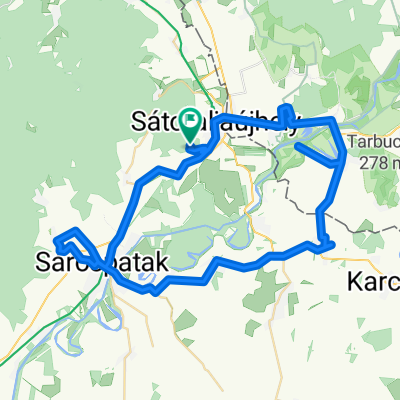
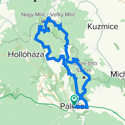
Pálháza-Kazinczy Múzeum Széphalom-Pálháza
A cycling route starting in Sátoraljaújhely, Borsod-Abauj Zemplen county, Hungary.
Overview
About this route
- -:--
- Duration
- 22.2 km
- Distance
- 58 m
- Ascent
- 60 m
- Descent
- ---
- Avg. speed
- ---
- Avg. speed
Route quality
Waytypes & surfaces along the route
Waytypes
Cycleway
17.2 km
(78 %)
Quiet road
2.8 km
(13 %)
Surfaces
Paved
19 km
(86 %)
Asphalt
19 km
(86 %)
Paving stones
0.1 km
(<1 %)
Undefined
3.1 km
(14 %)
Continue with Bikemap
Use, edit, or download this cycling route
You would like to ride Pálháza-Kazinczy Múzeum Széphalom-Pálháza or customize it for your own trip? Here is what you can do with this Bikemap route:
Free features
- Save this route as favorite or in collections
- Copy & plan your own version of this route
- Sync your route with Garmin or Wahoo
Premium features
Free trial for 3 days, or one-time payment. More about Bikemap Premium.
- Navigate this route on iOS & Android
- Export a GPX / KML file of this route
- Create your custom printout (try it for free)
- Download this route for offline navigation
Discover more Premium features.
Get Bikemap PremiumFrom our community
Other popular routes starting in Sátoraljaújhely
- Kis hegyköz kör
- Distance
- 23 km
- Ascent
- 228 m
- Descent
- 228 m
- Location
- Sátoraljaújhely, Borsod-Abauj Zemplen county, Hungary
- Pálháza_Kéked_Pálháza
- Distance
- 57.4 km
- Ascent
- 818 m
- Descent
- 820 m
- Location
- Sátoraljaújhely, Borsod-Abauj Zemplen county, Hungary
- XP Borzás Oldal+Ördög völgy Gerendás Rétig
- Distance
- 32.2 km
- Ascent
- 898 m
- Descent
- 621 m
- Location
- Sátoraljaújhely, Borsod-Abauj Zemplen county, Hungary
- District of Trebišov - District of Košice I
- Distance
- 71.1 km
- Ascent
- 485 m
- Descent
- 376 m
- Location
- Sátoraljaújhely, Borsod-Abauj Zemplen county, Hungary
- Zemplen - 3 kilato
- Distance
- 76.6 km
- Ascent
- 787 m
- Descent
- 781 m
- Location
- Sátoraljaújhely, Borsod-Abauj Zemplen county, Hungary
- From Pálháza to Mogyoróska
- Distance
- 24.9 km
- Ascent
- 894 m
- Descent
- 446 m
- Location
- Sátoraljaújhely, Borsod-Abauj Zemplen county, Hungary
- Sátoraljaújhely to Fő utca 117, Tiszakanyár
- Distance
- 60.1 km
- Ascent
- 243 m
- Descent
- 294 m
- Location
- Sátoraljaújhely, Borsod-Abauj Zemplen county, Hungary
- OKT Nagy-Milici Kék 1
- Distance
- 16.1 km
- Ascent
- 640 m
- Descent
- 551 m
- Location
- Sátoraljaújhely, Borsod-Abauj Zemplen county, Hungary
Open it in the app