

Oberhof-Inselsberg-Rennsteig
A cycling route starting in Bad Salzungen, Thuringia, Germany.
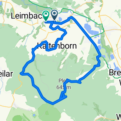
Overview
About this route
-mit dem Zug nach Oberhof und dann wieder über dem Rennsteig und Inselsberg nach Hause nach Salzungen.
- -:--
- Duration
- 129.6 km
- Distance
- 931 m
- Ascent
- 931 m
- Descent
- ---
- Avg. speed
- ---
- Max. altitude

Continue with Bikemap
Use, edit, or download this cycling route
You would like to ride Oberhof-Inselsberg-Rennsteig or customize it for your own trip? Here is what you can do with this Bikemap route:
Free features
- Save this route as favorite or in collections
- Copy & plan your own version of this route
- Split it into stages to create a multi-day tour
- Sync your route with Garmin or Wahoo
Premium features
Free trial for 3 days, or one-time payment. More about Bikemap Premium.
- Navigate this route on iOS & Android
- Export a GPX / KML file of this route
- Create your custom printout (try it for free)
- Download this route for offline navigation
Discover more Premium features.
Get Bikemap PremiumFrom our community
Other popular routes starting in Bad Salzungen
 13.07.24 Bad Salzungen-Hörschel
- Distance
- 79.9 km
- Ascent
- 289 m
- Descent
- 331 m
- Location
- Bad Salzungen, Thuringia, Germany
 Moorgrundrunde
- Distance
- 31.8 km
- Ascent
- 337 m
- Descent
- 337 m
- Location
- Bad Salzungen, Thuringia, Germany
 Pleßenduro
- Distance
- 36.3 km
- Ascent
- 910 m
- Descent
- 910 m
- Location
- Bad Salzungen, Thuringia, Germany
 Bad Salzungen // Walnusshof; Langenfelder Str. 2 nach Tropfsteinhöhle Kittelsthal und zurück
- Distance
- 51.4 km
- Ascent
- 823 m
- Descent
- 822 m
- Location
- Bad Salzungen, Thuringia, Germany
 Bad Salzungen Inselsberg und zurück
- Distance
- 56.9 km
- Ascent
- 937 m
- Descent
- 937 m
- Location
- Bad Salzungen, Thuringia, Germany
 Steinweg 2–10, Bad Salzungen nach Alleeweg 5G, Dermbach
- Distance
- 12.2 km
- Ascent
- 407 m
- Descent
- 351 m
- Location
- Bad Salzungen, Thuringia, Germany
 Pleßrunde
- Distance
- 34.5 km
- Ascent
- 450 m
- Descent
- 452 m
- Location
- Bad Salzungen, Thuringia, Germany
 2001 Werratal Bad Salzungen bis Gerstungen
- Distance
- 48.9 km
- Ascent
- 326 m
- Descent
- 354 m
- Location
- Bad Salzungen, Thuringia, Germany
Open it in the app