
Lützelburg gekürzt
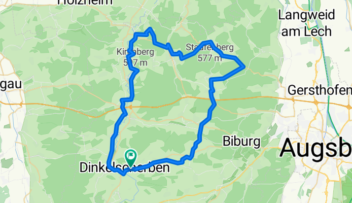
A cycling route starting in Dinkelscherben, Bavaria, Germany.
Overview
About this route
From Adelsried via Agawang new cycle path to Schempach. About half the elevation.
- -:--
- Duration
- 60.2 km
- Distance
- 304 m
- Ascent
- 304 m
- Descent
- ---
- Avg. speed
- ---
- Max. altitude

Route quality
Waytypes & surfaces along the route
Waytypes
Quiet road
19.9 km
(33 %)
Path
17.4 km
(29 %)
Surfaces
Paved
58.3 km
(97 %)
Unpaved
0.6 km
(1 %)
Asphalt
57.1 km
(95 %)
Paved (undefined)
1.2 km
(2 %)
Continue with Bikemap
Use, edit, or download this cycling route
You would like to ride Lützelburg gekürzt or customize it for your own trip? Here is what you can do with this Bikemap route:
Free features
- Save this route as favorite or in collections
- Copy & plan your own version of this route
- Sync your route with Garmin or Wahoo
Premium features
Free trial for 3 days, or one-time payment. More about Bikemap Premium.
- Navigate this route on iOS & Android
- Export a GPX / KML file of this route
- Create your custom printout (try it for free)
- Download this route for offline navigation
Discover more Premium features.
Get Bikemap PremiumFrom our community
Other popular routes starting in Dinkelscherben
 Rennrad-Tour "In-die-Stauden"
- Distance
- 53.8 km
- Ascent
- 415 m
- Descent
- 410 m
- Location
- Dinkelscherben, Bavaria, Germany
 Rennradtour von Dinkelscherben nach Maria Steinbach
- Distance
- 174.6 km
- Ascent
- 855 m
- Descent
- 852 m
- Location
- Dinkelscherben, Bavaria, Germany
 Dinkelscherben-Burgau (kurz)
- Distance
- 54.8 km
- Ascent
- 350 m
- Descent
- 330 m
- Location
- Dinkelscherben, Bavaria, Germany
 RSDD Grimoldsried - RSDD Grimoldsried
- Distance
- 62 km
- Ascent
- 725 m
- Descent
- 728 m
- Location
- Dinkelscherben, Bavaria, Germany
 Westliche Wälder Dinkelscherben Zusmarshausen Diedorf
- Distance
- 47.9 km
- Ascent
- 450 m
- Descent
- 452 m
- Location
- Dinkelscherben, Bavaria, Germany
 Stauden_extrem light
- Distance
- 86.7 km
- Ascent
- 711 m
- Descent
- 713 m
- Location
- Dinkelscherben, Bavaria, Germany
 Rennrad-Tour Dinkelscherben - Jettingen - Burtenbach
- Distance
- 44.5 km
- Ascent
- 332 m
- Descent
- 316 m
- Location
- Dinkelscherben, Bavaria, Germany
 Cappuccino Training lang 05.09.2020
- Distance
- 71.1 km
- Ascent
- 338 m
- Descent
- 340 m
- Location
- Dinkelscherben, Bavaria, Germany
Open it in the app