

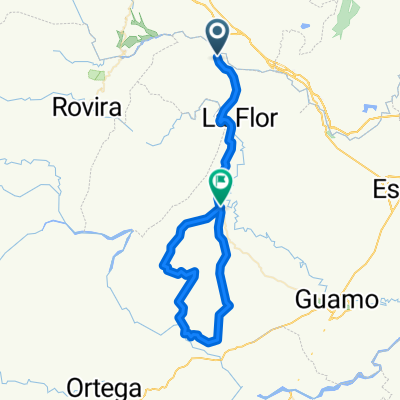
ruta sur 3pm
A cycling route starting in Valle de San Juan, Tolima Department, Colombia.
Overview
About this route
- 1 h 29 min
- Duration
- 36.8 km
- Distance
- 702 m
- Ascent
- 208 m
- Descent
- 24.7 km/h
- Avg. speed
- ---
- Max. altitude
Route quality
Waytypes & surfaces along the route
Waytypes
Cycleway
14 km
(38 %)
Quiet road
7 km
(19 %)
Surfaces
Paved
29.4 km
(80 %)
Unpaved
1.1 km
(3 %)
Asphalt
24.6 km
(67 %)
Paved (undefined)
3.3 km
(9 %)
Continue with Bikemap
Use, edit, or download this cycling route
You would like to ride ruta sur 3pm or customize it for your own trip? Here is what you can do with this Bikemap route:
Free features
- Save this route as favorite or in collections
- Copy & plan your own version of this route
- Sync your route with Garmin or Wahoo
Premium features
Free trial for 3 days, or one-time payment. More about Bikemap Premium.
- Navigate this route on iOS & Android
- Export a GPX / KML file of this route
- Create your custom printout (try it for free)
- Download this route for offline navigation
Discover more Premium features.
Get Bikemap PremiumFrom our community
Other popular routes starting in Valle de San Juan
 Parteee 2
- Distance
- 53.3 km
- Ascent
- 1,253 m
- Descent
- 640 m
- Location
- Valle de San Juan, Tolima Department, Colombia
 San Luis Ciclismo
- Distance
- 72.9 km
- Ascent
- 577 m
- Descent
- 792 m
- Location
- Valle de San Juan, Tolima Department, Colombia
 ruta sur 3pm
- Distance
- 36.8 km
- Ascent
- 702 m
- Descent
- 208 m
- Location
- Valle de San Juan, Tolima Department, Colombia
 De Variante Ibagué - Armenia a Vía Aeropuerto Perales, Ibagué
- Distance
- 16 km
- Ascent
- 321 m
- Descent
- 67 m
- Location
- Valle de San Juan, Tolima Department, Colombia
 De Carrera 5ª 7-06, Valle de San Juan a Rovira
- Distance
- 14.6 km
- Ascent
- 405 m
- Descent
- 320 m
- Location
- Valle de San Juan, Tolima Department, Colombia
 Payande, San Luis to Calle 65 20-1–20-99, Ibagué
- Distance
- 37.8 km
- Ascent
- 627 m
- Descent
- 227 m
- Location
- Valle de San Juan, Tolima Department, Colombia
 Gran Fondo Ciudad Musical 100K
- Distance
- 100.6 km
- Ascent
- 903 m
- Descent
- 904 m
- Location
- Valle de San Juan, Tolima Department, Colombia
 Buenos Aires Las Cascadas
- Distance
- 14.7 km
- Ascent
- 311 m
- Descent
- 357 m
- Location
- Valle de San Juan, Tolima Department, Colombia
Open it in the app