

SW U.S.
2020 SW US Tour - Brawley to Blyth - Ride Day 4
A cycling route starting in Brawley, California, United States.
Overview
About this route
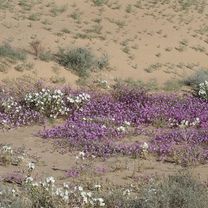
This was a marathon 90 mile ride through beautful countryside. Much of the road had excellent shoulder, but there was a reasonably long section in the middle that had little or no shoulder.
The ride went thorugh agricultural areas, sand dunes, and beautiful desert.
As there's not much between Brawley and Blyth, bring plenty of water. There are stores in Glamis and Palo Verde where one can buy water, but don't depend on them to be open.
- -:--
- Duration
- 142.9 km
- Distance
- 347 m
- Ascent
- 266 m
- Descent
- ---
- Avg. speed
- ---
- Max. altitude

Part of
11 stages
Route photos


Continue with Bikemap
Use, edit, or download this cycling route
You would like to ride 2020 SW US Tour - Brawley to Blyth - Ride Day 4 or customize it for your own trip? Here is what you can do with this Bikemap route:
Free features
- Save this route as favorite or in collections
- Copy & plan your own version of this route
- Split it into stages to create a multi-day tour
- Sync your route with Garmin or Wahoo
Premium features
Free trial for 3 days, or one-time payment. More about Bikemap Premium.
- Navigate this route on iOS & Android
- Export a GPX / KML file of this route
- Create your custom printout (try it for free)
- Download this route for offline navigation
Discover more Premium features.
Get Bikemap PremiumFrom our community
Other popular routes starting in Brawley
 13. Brawley - North Peak
- Distance
- 184.7 km
- Ascent
- 2,533 m
- Descent
- 716 m
- Location
- Brawley, California, United States
 Cross Country 4/12/21
- Distance
- 116.2 km
- Ascent
- 1,518 m
- Descent
- 227 m
- Location
- Brawley, California, United States
 Jones Street 1141, Brawley to Mesquite Avenue 1158, Brawley
- Distance
- 3.3 km
- Ascent
- 22 m
- Descent
- 23 m
- Location
- Brawley, California, United States
 Brawley, CA - Boulevard, CA
- Distance
- 109 km
- Ascent
- 1,278 m
- Descent
- 144 m
- Location
- Brawley, California, United States
 Brawley - Blythe
- Distance
- 150.9 km
- Ascent
- 388 m
- Descent
- 305 m
- Location
- Brawley, California, United States
 03 - RAAM - Blythe, CA
- Distance
- 144.4 km
- Ascent
- 434 m
- Descent
- 318 m
- Location
- Brawley, California, United States
 2020 SW US Tour - Brawley to Blyth - Ride Day 4
- Distance
- 142.9 km
- Ascent
- 347 m
- Descent
- 266 m
- Location
- Brawley, California, United States
 TS02-TS03
- Distance
- 144.4 km
- Ascent
- 384 m
- Descent
- 304 m
- Location
- Brawley, California, United States
Open it in the app