
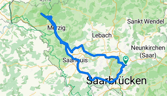
Sulzbach/Saar - Burg Montclair
A cycling route starting in Sulzbach, Saarland, Germany.
Overview
About this route
Hinweg am Saarradweg, zurück über kürzeste Straßenverbindung
- -:--
- Duration
- 128.3 km
- Distance
- 544 m
- Ascent
- 544 m
- Descent
- ---
- Avg. speed
- ---
- Max. altitude
Route quality
Waytypes & surfaces along the route
Waytypes
Busy road
31.7 km
(25 %)
Path
25.1 km
(20 %)
Surfaces
Paved
100.1 km
(78 %)
Unpaved
15.7 km
(12 %)
Asphalt
75.6 km
(59 %)
Paved (undefined)
12.4 km
(10 %)
Continue with Bikemap
Use, edit, or download this cycling route
You would like to ride Sulzbach/Saar - Burg Montclair or customize it for your own trip? Here is what you can do with this Bikemap route:
Free features
- Save this route as favorite or in collections
- Copy & plan your own version of this route
- Split it into stages to create a multi-day tour
- Sync your route with Garmin or Wahoo
Premium features
Free trial for 3 days, or one-time payment. More about Bikemap Premium.
- Navigate this route on iOS & Android
- Export a GPX / KML file of this route
- Create your custom printout (try it for free)
- Download this route for offline navigation
Discover more Premium features.
Get Bikemap PremiumFrom our community
Other popular routes starting in Sulzbach
 Kurze Runde durch Lothringen
- Distance
- 39.9 km
- Ascent
- 444 m
- Descent
- 444 m
- Location
- Sulzbach, Saarland, Germany
 Weiherrunde um SB
- Distance
- 34.4 km
- Ascent
- 332 m
- Descent
- 332 m
- Location
- Sulzbach, Saarland, Germany
 Neuweiler 7 Weiher Tour
- Distance
- 42.3 km
- Ascent
- 497 m
- Descent
- 506 m
- Location
- Sulzbach, Saarland, Germany
 lidija
- Distance
- 3.8 km
- Ascent
- 90 m
- Descent
- 127 m
- Location
- Sulzbach, Saarland, Germany
 Zwischen Dudweiler und St. Ingbert
- Distance
- 21.7 km
- Ascent
- 546 m
- Descent
- 479 m
- Location
- Sulzbach, Saarland, Germany
 Vorbei am Rohrbach Saar und Fischbach
- Distance
- 41.9 km
- Ascent
- 529 m
- Descent
- 527 m
- Location
- Sulzbach, Saarland, Germany
 BrennenderBerg
- Distance
- 20.3 km
- Ascent
- 473 m
- Descent
- 473 m
- Location
- Sulzbach, Saarland, Germany
 Wandern Netzbachweiher-Hirschgrabenweiher 5,5 km
- Distance
- 5.3 km
- Ascent
- 82 m
- Descent
- 89 m
- Location
- Sulzbach, Saarland, Germany
Open it in the app