

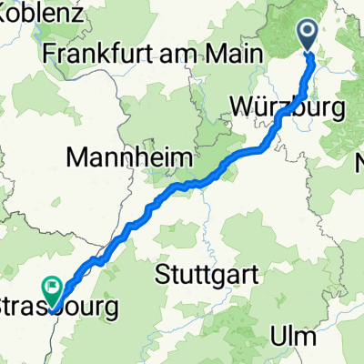
Bischofsheim - Würzburg
A cycling route starting in Oerlenbach, Bavaria, Germany.
Overview
About this route
Oerlenbach - Münnerstadt - Neustadt - Bischofsheim - Sinntal - Gemünden - Maindreieck to Schweinfurt - Oerlenbach
- -:--
- Duration
- 268.6 km
- Distance
- 1,174 m
- Ascent
- 1,169 m
- Descent
- ---
- Avg. speed
- ---
- Max. altitude
Continue with Bikemap
Use, edit, or download this cycling route
You would like to ride Bischofsheim - Würzburg or customize it for your own trip? Here is what you can do with this Bikemap route:
Free features
- Save this route as favorite or in collections
- Copy & plan your own version of this route
- Split it into stages to create a multi-day tour
- Sync your route with Garmin or Wahoo
Premium features
Free trial for 3 days, or one-time payment. More about Bikemap Premium.
- Navigate this route on iOS & Android
- Export a GPX / KML file of this route
- Create your custom printout (try it for free)
- Download this route for offline navigation
Discover more Premium features.
Get Bikemap PremiumFrom our community
Other popular routes starting in Oerlenbach
 Rosenstraße 30, Oerlenbach nach Bayernstraße 49, Oerlenbach
- Distance
- 10.4 km
- Ascent
- 95 m
- Descent
- 106 m
- Location
- Oerlenbach, Bavaria, Germany
 Oerlenbacher Straße 11 nach Im Gereuth 10, Oerlenbach
- Distance
- 38.2 km
- Ascent
- 393 m
- Descent
- 397 m
- Location
- Oerlenbach, Bavaria, Germany
 mtbdriver Hausstrecke
- Distance
- 28.1 km
- Ascent
- 254 m
- Descent
- 254 m
- Location
- Oerlenbach, Bavaria, Germany
 Hennebergstraße 33, Oerlenbach nach Reichenbacher Straße, Münnerstadt
- Distance
- 24.2 km
- Ascent
- 174 m
- Descent
- 275 m
- Location
- Oerlenbach, Bavaria, Germany
 Kleine Werntalrunde
- Distance
- 24.2 km
- Ascent
- 263 m
- Descent
- 268 m
- Location
- Oerlenbach, Bavaria, Germany
 Wittisheim - Straßburg
- Distance
- 311.6 km
- Ascent
- 2,595 m
- Descent
- 2,795 m
- Location
- Oerlenbach, Bavaria, Germany
 Bischofsheim - Würzburg
- Distance
- 268.6 km
- Ascent
- 1,174 m
- Descent
- 1,169 m
- Location
- Oerlenbach, Bavaria, Germany
 Thalkirche
- Distance
- 35.7 km
- Ascent
- 382 m
- Descent
- 381 m
- Location
- Oerlenbach, Bavaria, Germany
Open it in the app