
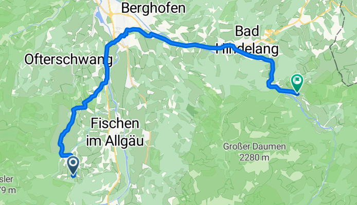
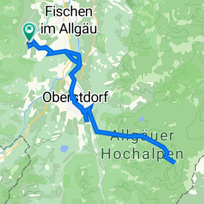
Ostein-Hinterstein
A cycling route starting in Obermaiselstein, Bavaria, Germany.
Overview
About this route
- -:--
- Duration
- 23.3 km
- Distance
- 216 m
- Ascent
- 179 m
- Descent
- ---
- Avg. speed
- ---
- Max. altitude
Route quality
Waytypes & surfaces along the route
Waytypes
Quiet road
8.6 km
(37 %)
Road
8.4 km
(36 %)
Surfaces
Paved
18.9 km
(81 %)
Asphalt
18.9 km
(81 %)
Undefined
4.4 km
(19 %)
Continue with Bikemap
Use, edit, or download this cycling route
You would like to ride Ostein-Hinterstein or customize it for your own trip? Here is what you can do with this Bikemap route:
Free features
- Save this route as favorite or in collections
- Copy & plan your own version of this route
- Sync your route with Garmin or Wahoo
Premium features
Free trial for 3 days, or one-time payment. More about Bikemap Premium.
- Navigate this route on iOS & Android
- Export a GPX / KML file of this route
- Create your custom printout (try it for free)
- Download this route for offline navigation
Discover more Premium features.
Get Bikemap PremiumFrom our community
Other popular routes starting in Obermaiselstein
 AT - Transalp - Obersdorf - Riva del Garda
- Distance
- 358.3 km
- Ascent
- 6,190 m
- Descent
- 6,888 m
- Location
- Obermaiselstein, Bavaria, Germany
 Riedbergpass - Sibratsgfäll
- Distance
- 56.1 km
- Ascent
- 1,607 m
- Descent
- 1,521 m
- Location
- Obermaiselstein, Bavaria, Germany
 Oytal/ Wasserfall
- Distance
- 39.9 km
- Ascent
- 798 m
- Descent
- 787 m
- Location
- Obermaiselstein, Bavaria, Germany
 kurze Riedbergpassrunde
- Distance
- 75 km
- Ascent
- 1,076 m
- Descent
- 1,332 m
- Location
- Obermaiselstein, Bavaria, Germany
 Piesenalp
- Distance
- 17.5 km
- Ascent
- 665 m
- Descent
- 89 m
- Location
- Obermaiselstein, Bavaria, Germany
 Riedbergpass - Balderschwang - Höllritzer Alpe
- Distance
- 42.7 km
- Ascent
- 1,199 m
- Descent
- 1,202 m
- Location
- Obermaiselstein, Bavaria, Germany
 Allgäu Oberstdorfer Tälerrunde as ridden
- Distance
- 27.4 km
- Ascent
- 266 m
- Descent
- 376 m
- Location
- Obermaiselstein, Bavaria, Germany
 Ostein-Hinterstein
- Distance
- 23.3 km
- Ascent
- 216 m
- Descent
- 179 m
- Location
- Obermaiselstein, Bavaria, Germany
Open it in the app