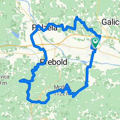
Kolesarjenje po Spodnji Savinjski dolini
A cycling route starting in Žalec, Občina Žalec, Slovenia.
Overview
About this route
- -:--
- Duration
- 50.6 km
- Distance
- 269 m
- Ascent
- 269 m
- Descent
- ---
- Avg. speed
- ---
- Avg. speed
Route quality
Waytypes & surfaces along the route
Waytypes
Quiet road
26 km
(51 %)
Road
15.7 km
(31 %)
Surfaces
Paved
19.6 km
(39 %)
Asphalt
19.6 km
(39 %)
Undefined
31.1 km
(61 %)
Continue with Bikemap
Use, edit, or download this cycling route
You would like to ride Kolesarjenje po Spodnji Savinjski dolini or customize it for your own trip? Here is what you can do with this Bikemap route:
Free features
- Save this route as favorite or in collections
- Copy & plan your own version of this route
- Sync your route with Garmin or Wahoo
Premium features
Free trial for 3 days, or one-time payment. More about Bikemap Premium.
- Navigate this route on iOS & Android
- Export a GPX / KML file of this route
- Create your custom printout (try it for free)
- Download this route for offline navigation
Discover more Premium features.
Get Bikemap PremiumFrom our community
Other popular routes starting in Žalec
- Kolesarjenje po Spodnji Savinjski dolini
- Distance
- 50.6 km
- Ascent
- 269 m
- Descent
- 269 m
- Location
- Žalec, Občina Žalec, Slovenia
- HopsNaHom
- Distance
- 22.3 km
- Ascent
- 422 m
- Descent
- 419 m
- Location
- Žalec, Občina Žalec, Slovenia
- Zicer - Kraljevska 2022 (Žalec-Griže-Prebold-Dom pod Reško planino-Podmeja-Mrzlica-Žalec)
- Distance
- 49.9 km
- Ascent
- 1,346 m
- Descent
- 1,347 m
- Location
- Žalec, Občina Žalec, Slovenia
- Restful route in Žalec
- Distance
- 25.5 km
- Ascent
- 448 m
- Descent
- 469 m
- Location
- Žalec, Občina Žalec, Slovenia
- PO DOLENJSKEM
- Distance
- 356.6 km
- Ascent
- 2,290 m
- Descent
- 2,290 m
- Location
- Žalec, Občina Žalec, Slovenia
- Usrano jezero
- Distance
- 698.3 km
- Ascent
- 502 m
- Descent
- 475 m
- Location
- Žalec, Občina Žalec, Slovenia
- TURA 2024 VIŠARJE
- Distance
- 478.3 km
- Ascent
- 8,471 m
- Descent
- 8,469 m
- Location
- Žalec, Občina Žalec, Slovenia
- GrossGlockner Ciril
- Distance
- 952 km
- Ascent
- 3,159 m
- Descent
- 3,158 m
- Location
- Žalec, Občina Žalec, Slovenia
Open it in the app