

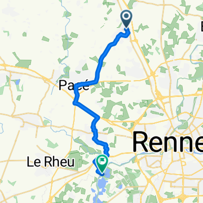
1 Allée de la Hamonière, La Chapelle-des-Fougeretz to 7 Boulevard de la Boutière, Saint-Grégoire
A cycling route starting in La Chapelle-des-Fougeretz, Brittany Region, France.
Overview
About this route
- 26 min
- Duration
- 7.5 km
- Distance
- 29 m
- Ascent
- 80 m
- Descent
- 17.2 km/h
- Avg. speed
- ---
- Max. altitude

Route quality
Waytypes & surfaces along the route
Waytypes
Road
4.4 km
(58 %)
Cycleway
1.1 km
(14 %)
Surfaces
Paved
6.3 km
(84 %)
Asphalt
5.5 km
(73 %)
Concrete
0.8 km
(11 %)
Undefined
1.2 km
(16 %)
Continue with Bikemap
Use, edit, or download this cycling route
You would like to ride 1 Allée de la Hamonière, La Chapelle-des-Fougeretz to 7 Boulevard de la Boutière, Saint-Grégoire or customize it for your own trip? Here is what you can do with this Bikemap route:
Free features
- Save this route as favorite or in collections
- Copy & plan your own version of this route
- Sync your route with Garmin or Wahoo
Premium features
Free trial for 3 days, or one-time payment. More about Bikemap Premium.
- Navigate this route on iOS & Android
- Export a GPX / KML file of this route
- Create your custom printout (try it for free)
- Download this route for offline navigation
Discover more Premium features.
Get Bikemap PremiumFrom our community
Other popular routes starting in La Chapelle-des-Fougeretz
 Avenue du Phare du Grand Jardin, Melesse to Le Verger Beaucé, Melesse
- Distance
- 4 km
- Ascent
- 24 m
- Descent
- 36 m
- Location
- La Chapelle-des-Fougeretz, Brittany Region, France
 Tout droit à l'intérieur Rennes
- Distance
- 13.4 km
- Ascent
- 68 m
- Descent
- 105 m
- Location
- La Chapelle-des-Fougeretz, Brittany Region, France
 Route stable en Saint-Grégoire ´ Mme
- Distance
- 7.9 km
- Ascent
- 36 m
- Descent
- 85 m
- Location
- La Chapelle-des-Fougeretz, Brittany Region, France
 1 Rue du Plessis Carrel, La Chapelle-des-Fougeretz à 36 Rue des Courtines, Montgermont
- Distance
- 4 km
- Ascent
- 9 m
- Descent
- 40 m
- Location
- La Chapelle-des-Fougeretz, Brittany Region, France
 De Langerais, Pacé à Champ de Langerais, Pacé
- Distance
- 13.6 km
- Ascent
- 70 m
- Descent
- 118 m
- Location
- La Chapelle-des-Fougeretz, Brittany Region, France
 ALLER AU CHP
- Distance
- 7.1 km
- Ascent
- 35 m
- Descent
- 80 m
- Location
- La Chapelle-des-Fougeretz, Brittany Region, France
 Étang D ‘Apigné
- Distance
- 15 km
- Ascent
- 66 m
- Descent
- 154 m
- Location
- La Chapelle-des-Fougeretz, Brittany Region, France
 Supersonic route in Saint-Grégoire
- Distance
- 7.2 km
- Ascent
- 32 m
- Descent
- 79 m
- Location
- La Chapelle-des-Fougeretz, Brittany Region, France
Open it in the app