

Vysoká pri Morave - Bratislava
A cycling route starting in Stupava, Bratislava Region, Slovakia.
Overview
About this route
- -:--
- Duration
- 32.2 km
- Distance
- 47 m
- Ascent
- 52 m
- Descent
- ---
- Avg. speed
- ---
- Max. altitude

Route quality
Waytypes & surfaces along the route
Waytypes
Cycleway
8.7 km
(27 %)
Track
8.4 km
(26 %)
Surfaces
Paved
30.5 km
(95 %)
Unpaved
0.3 km
(1 %)
Asphalt
29.3 km
(91 %)
Paved (undefined)
0.6 km
(2 %)
Continue with Bikemap
Use, edit, or download this cycling route
You would like to ride Vysoká pri Morave - Bratislava or customize it for your own trip? Here is what you can do with this Bikemap route:
Free features
- Save this route as favorite or in collections
- Copy & plan your own version of this route
- Sync your route with Garmin or Wahoo
Premium features
Free trial for 3 days, or one-time payment. More about Bikemap Premium.
- Navigate this route on iOS & Android
- Export a GPX / KML file of this route
- Create your custom printout (try it for free)
- Download this route for offline navigation
Discover more Premium features.
Get Bikemap PremiumFrom our community
Other popular routes starting in Stupava
 Zoboty
- Distance
- 34.3 km
- Ascent
- 102 m
- Descent
- 92 m
- Location
- Stupava, Bratislava Region, Slovakia
 Slovenská do Janka Kráľa 1000/6
- Distance
- 53.1 km
- Ascent
- 695 m
- Descent
- 725 m
- Location
- Stupava, Bratislava Region, Slovakia
 30 km okruh
- Distance
- 30.2 km
- Ascent
- 484 m
- Descent
- 484 m
- Location
- Stupava, Bratislava Region, Slovakia
 Dovolenka_2013
- Distance
- 1,204.3 km
- Ascent
- 2,621 m
- Descent
- 2,487 m
- Location
- Stupava, Bratislava Region, Slovakia
 Stupava, Stupava to Old Town, Bratislava I
- Distance
- 32.5 km
- Ascent
- 107 m
- Descent
- 132 m
- Location
- Stupava, Bratislava Region, Slovakia
 DNV-Záhorská Ves-okruh v Rakúsku-Záhorská Ves-DNV
- Distance
- 175.5 km
- Ascent
- 697 m
- Descent
- 697 m
- Location
- Stupava, Bratislava Region, Slovakia
 Riadok do Riadok
- Distance
- 21.4 km
- Ascent
- 272 m
- Descent
- 326 m
- Location
- Stupava, Bratislava Region, Slovakia
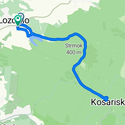
 ride through Lozorno
- Distance
- 23.1 km
- Ascent
- 282 m
- Descent
- 282 m
- Location
- Stupava, Bratislava Region, Slovakia
Open it in the app