

Monteriggioni-Siena-Castello di Brolio-Vagliagli-Monteriggioni
A cycling route starting in Monteriggioni, Tuscany, Italy.
Overview
About this route
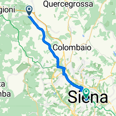
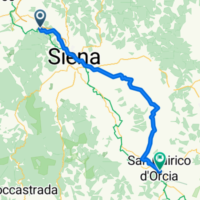
From Monteriggioni, you reach Badesse, then via a provincial road, Il Beccio. A short stretch along Cassa Nord until Fontebecci, where we take Via Fiorentina that leads us to Porta Camollia, at the gates of the center of Siena. The route arrives at Piazza del Campo with a wide detour due to one-way streets, but from Porta Camollia, with a bit of attention, one can cross the center (of course with the bike in hand in the busiest sections). We leave Siena through Porta Romana and take a left on Strada della Certosa, a beautiful panoramic road that, unfortunately, we leave soon to head to the road of Pieve a Bozzone. We follow it for about 5 km until we turn left onto the road of Montechiaro that leads us to the outskirts of San Giovanni a Cerreto. We turn right and reach Pianella, continue for a little over 1 km on SP di Montevarchi and then turn right onto SC 24 which in 9 km of ascent takes us to Castello di Brolio and to Trivio di La Madonna. We take the first left towards Gaiole in Chianti for about 5 km, then, instead of going right to Gaiole, we turn left to Osteria della Passera and at the next fork we go right towards Lecchi (in the direction of Radda in Chianti). At the next important fork (just before Radda), we go left on Strada Arco del Castello and reach Vagliagli. The long climbs are over, now downhill and rolling sections to Querciagrossa and Lornano, then Castellina Scalo and back to Monteriggioni.
- -:--
- Duration
- 85.7 km
- Distance
- 1,044 m
- Ascent
- 1,105 m
- Descent
- ---
- Avg. speed
- ---
- Max. altitude
Route quality
Waytypes & surfaces along the route
Waytypes
Road
40.3 km
(47 %)
Quiet road
15.4 km
(18 %)
Surfaces
Paved
56.5 km
(66 %)
Unpaved
21.4 km
(25 %)
Asphalt
55.7 km
(65 %)
Gravel
12 km
(14 %)
Continue with Bikemap
Use, edit, or download this cycling route
You would like to ride Monteriggioni-Siena-Castello di Brolio-Vagliagli-Monteriggioni or customize it for your own trip? Here is what you can do with this Bikemap route:
Free features
- Save this route as favorite or in collections
- Copy & plan your own version of this route
- Split it into stages to create a multi-day tour
- Sync your route with Garmin or Wahoo
Premium features
Free trial for 3 days, or one-time payment. More about Bikemap Premium.
- Navigate this route on iOS & Android
- Export a GPX / KML file of this route
- Create your custom printout (try it for free)
- Download this route for offline navigation
Discover more Premium features.
Get Bikemap PremiumFrom our community
Other popular routes starting in Monteriggioni
 giro definitivo
- Distance
- 87.6 km
- Ascent
- 1,070 m
- Descent
- 1,070 m
- Location
- Monteriggioni, Tuscany, Italy
 Monteriggioni-Siena-Castello di Brolio-Vagliagli-Monteriggioni
- Distance
- 85.7 km
- Ascent
- 1,044 m
- Descent
- 1,105 m
- Location
- Monteriggioni, Tuscany, Italy
 Monteriggioni - Siena
- Distance
- 11 km
- Ascent
- 246 m
- Descent
- 135 m
- Location
- Monteriggioni, Tuscany, Italy
 TOSKANA 1.MAJ
- Distance
- 156.5 km
- Ascent
- 1,662 m
- Descent
- 1,709 m
- Location
- Monteriggioni, Tuscany, Italy
 Roma, Monteriggioni naar Strada di Toiano, Sovicille
- Distance
- 14 km
- Ascent
- 251 m
- Descent
- 277 m
- Location
- Monteriggioni, Tuscany, Italy
 Around San Gimignano (reversed)
- Distance
- 63.6 km
- Ascent
- 653 m
- Descent
- 652 m
- Location
- Monteriggioni, Tuscany, Italy
 Strada Comunale di Monteriggioni to Via Dante Alighieri 111A
- Distance
- 71.1 km
- Ascent
- 1,451 m
- Descent
- 1,307 m
- Location
- Monteriggioni, Tuscany, Italy
 Quick bike tour through Monteriggioni
- Distance
- 19.8 km
- Ascent
- 193 m
- Descent
- 457 m
- Location
- Monteriggioni, Tuscany, Italy
Open it in the app