

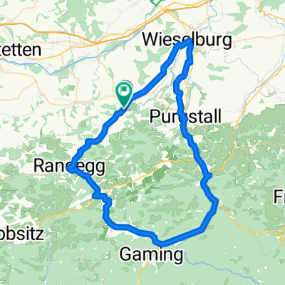
Mostviertler Schlössertour Ost
A cycling route starting in Wolfpassing, Lower Austria, Austria.
Overview
About this route
Source: Radatlas Mostviertel 4 F,G,H or 10 D,E,C
- -:--
- Duration
- 56.4 km
- Distance
- 928 m
- Ascent
- 940 m
- Descent
- ---
- Avg. speed
- ---
- Max. altitude

Route quality
Waytypes & surfaces along the route
Waytypes
Quiet road
19.2 km
(34 %)
Road
17.5 km
(31 %)
Surfaces
Paved
46.2 km
(82 %)
Unpaved
2.3 km
(4 %)
Asphalt
44 km
(78 %)
Paved (undefined)
2.3 km
(4 %)
Continue with Bikemap
Use, edit, or download this cycling route
You would like to ride Mostviertler Schlössertour Ost or customize it for your own trip? Here is what you can do with this Bikemap route:
Free features
- Save this route as favorite or in collections
- Copy & plan your own version of this route
- Sync your route with Garmin or Wahoo
Premium features
Free trial for 3 days, or one-time payment. More about Bikemap Premium.
- Navigate this route on iOS & Android
- Export a GPX / KML file of this route
- Create your custom printout (try it for free)
- Download this route for offline navigation
Discover more Premium features.
Get Bikemap PremiumFrom our community
Other popular routes starting in Wolfpassing
 MERIDIANWEG III
- Distance
- 48.4 km
- Ascent
- 837 m
- Descent
- 836 m
- Location
- Wolfpassing, Lower Austria, Austria
 steinakirchen Hochkar
- Distance
- 168.3 km
- Ascent
- 1,327 m
- Descent
- 1,320 m
- Location
- Wolfpassing, Lower Austria, Austria
 Wolfpassing 95 nach Panoramagasse 16, Steinakirchen am Forst
- Distance
- 33.2 km
- Ascent
- 865 m
- Descent
- 816 m
- Location
- Wolfpassing, Lower Austria, Austria
 steinakirchen-blima
- Distance
- 10.5 km
- Ascent
- 62 m
- Descent
- 164 m
- Location
- Wolfpassing, Lower Austria, Austria
 Grein
Grein- Distance
- 70.8 km
- Ascent
- 391 m
- Descent
- 389 m
- Location
- Wolfpassing, Lower Austria, Austria
 Zehethof-Tour mit Hausberg
- Distance
- 10.6 km
- Ascent
- 145 m
- Descent
- 145 m
- Location
- Wolfpassing, Lower Austria, Austria
 Radrunde durch Steinakirchen am Forst
- Distance
- 20 km
- Ascent
- 190 m
- Descent
- 190 m
- Location
- Wolfpassing, Lower Austria, Austria
 Kleines+Großes Erlauftal Start : Steinakirchen am Forst
- Distance
- 67.6 km
- Ascent
- 697 m
- Descent
- 697 m
- Location
- Wolfpassing, Lower Austria, Austria
Open it in the app