

Biały Śląsk. Przez lasy lublinieckie
A cycling route starting in Radzionków, Silesian Voivodeship, Poland.
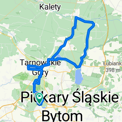
Overview
About this route
- -:--
- Duration
- 86.2 km
- Distance
- 574 m
- Ascent
- 574 m
- Descent
- ---
- Avg. speed
- ---
- Max. altitude

Route photos

Route quality
Waytypes & surfaces along the route
Waytypes
Track
30.2 km
(35 %)
Quiet road
23.3 km
(27 %)
Surfaces
Paved
25.9 km
(30 %)
Unpaved
19 km
(22 %)
Asphalt
23.3 km
(27 %)
Gravel
9.5 km
(11 %)
Continue with Bikemap
Use, edit, or download this cycling route
You would like to ride Biały Śląsk. Przez lasy lublinieckie or customize it for your own trip? Here is what you can do with this Bikemap route:
Free features
- Save this route as favorite or in collections
- Copy & plan your own version of this route
- Split it into stages to create a multi-day tour
- Sync your route with Garmin or Wahoo
Premium features
Free trial for 3 days, or one-time payment. More about Bikemap Premium.
- Navigate this route on iOS & Android
- Export a GPX / KML file of this route
- Create your custom printout (try it for free)
- Download this route for offline navigation
Discover more Premium features.
Get Bikemap PremiumFrom our community
Other popular routes starting in Radzionków
 Zalana kopalnia przez Pyrzowice
- Distance
- 46.9 km
- Ascent
- 170 m
- Descent
- 171 m
- Location
- Radzionków, Silesian Voivodeship, Poland
 Biały Śląsk. Przez lasy lublinieckie
- Distance
- 86.2 km
- Ascent
- 574 m
- Descent
- 574 m
- Location
- Radzionków, Silesian Voivodeship, Poland
 Historycznie po północnych obrzeżach GOP
- Distance
- 84.5 km
- Ascent
- 525 m
- Descent
- 523 m
- Location
- Radzionków, Silesian Voivodeship, Poland
 Route in Bytom
- Distance
- 73.5 km
- Ascent
- 366 m
- Descent
- 368 m
- Location
- Radzionków, Silesian Voivodeship, Poland
 Miechowice - Zbrosławice Bunkier 31.05.2012
- Distance
- 29 km
- Ascent
- 181 m
- Descent
- 182 m
- Location
- Radzionków, Silesian Voivodeship, Poland
 W lublinieckie lasy - podróż sentymentalna
- Distance
- 98.7 km
- Ascent
- 717 m
- Descent
- 715 m
- Location
- Radzionków, Silesian Voivodeship, Poland
 Z synem najlepiej :)
- Distance
- 12.2 km
- Ascent
- 95 m
- Descent
- 98 m
- Location
- Radzionków, Silesian Voivodeship, Poland
 Po regionalnych zalewach i stawach
- Distance
- 37.1 km
- Ascent
- 185 m
- Descent
- 185 m
- Location
- Radzionków, Silesian Voivodeship, Poland
Open it in the app