

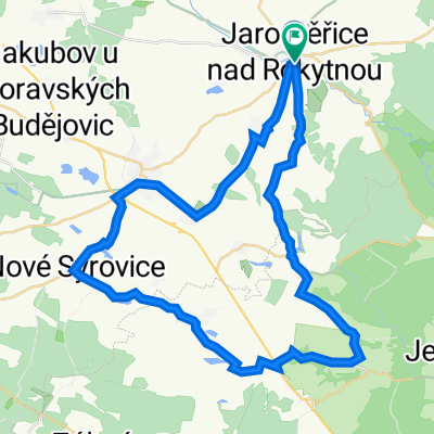
Jaroměřice Opatov Rosička Jihlava
A cycling route starting in Jaroměřice nad Rokytnou, Kraj Vysočina, Czechia.
Overview
About this route
The more information you write here, the more useful it will be for other users.* Route progression.* What is special about this route?* Why recommend this route?* What did you like most about it here?* Etc.
- -:--
- Duration
- 67.1 km
- Distance
- 700 m
- Ascent
- 627 m
- Descent
- ---
- Avg. speed
- ---
- Max. altitude

Route quality
Waytypes & surfaces along the route
Waytypes
Track
24.8 km
(37 %)
Road
22.1 km
(33 %)
Surfaces
Paved
14.8 km
(22 %)
Unpaved
15.4 km
(23 %)
Asphalt
10.7 km
(16 %)
Gravel
7.4 km
(11 %)
Continue with Bikemap
Use, edit, or download this cycling route
You would like to ride Jaroměřice Opatov Rosička Jihlava or customize it for your own trip? Here is what you can do with this Bikemap route:
Free features
- Save this route as favorite or in collections
- Copy & plan your own version of this route
- Sync your route with Garmin or Wahoo
Premium features
Free trial for 3 days, or one-time payment. More about Bikemap Premium.
- Navigate this route on iOS & Android
- Export a GPX / KML file of this route
- Create your custom printout (try it for free)
- Download this route for offline navigation
Discover more Premium features.
Get Bikemap PremiumFrom our community
Other popular routes starting in Jaroměřice nad Rokytnou
 Jaroměřice Opatov Rosička Jihlava
- Distance
- 67.1 km
- Ascent
- 700 m
- Descent
- 627 m
- Location
- Jaroměřice nad Rokytnou, Kraj Vysočina, Czechia
 Chlapi sobě: Lipník - Náměšť
- Distance
- 26.7 km
- Ascent
- 252 m
- Descent
- 273 m
- Location
- Jaroměřice nad Rokytnou, Kraj Vysočina, Czechia
 Jaroměřice nad Rokytnou do Želetava
- Distance
- 17.7 km
- Ascent
- 261 m
- Descent
- 118 m
- Location
- Jaroměřice nad Rokytnou, Kraj Vysočina, Czechia
 Vacenovice a okolí
- Distance
- 25.6 km
- Ascent
- 193 m
- Descent
- 195 m
- Location
- Jaroměřice nad Rokytnou, Kraj Vysočina, Czechia
 Třebíč ?
- Distance
- 44.5 km
- Ascent
- 375 m
- Descent
- 366 m
- Location
- Jaroměřice nad Rokytnou, Kraj Vysočina, Czechia
 Krátká zámecká
- Distance
- 45.8 km
- Ascent
- 325 m
- Descent
- 325 m
- Location
- Jaroměřice nad Rokytnou, Kraj Vysočina, Czechia
 Jaroměřice nad Rokytnou Jihlava
- Distance
- 60 km
- Ascent
- 442 m
- Descent
- 371 m
- Location
- Jaroměřice nad Rokytnou, Kraj Vysočina, Czechia
 Jaroměrice nad Rokytnou - Třebíč - Jaroměrice nad Rokytnou
- Distance
- 38.4 km
- Ascent
- 313 m
- Descent
- 313 m
- Location
- Jaroměřice nad Rokytnou, Kraj Vysočina, Czechia
Open it in the app